What can lava tell us? Deciphering Kīlauea’s 2018 eruption through chemistry
The 2018 eruption on Kīlauea’s lower East Rift Zone spewed around a billion cubic yards of lava into Puna. From the moment the eruption began, samples of lava were collected and rapidly analyzed by a team of USGS Hawaiian Volcano Observatory and University of Hawaiʻi at Hilo scientists. Geologists Cheryl Gansecki (UH-Hilo) and Lopaka Lee (USGS-HVO) discuss how their work revealed the complex story of magma sources, both old and new, inside Kīlauea Volcano, and how certain chemical elements can provide insights useful for monitoring eruptive behavior in this Volcano Awareness Month video. Their talk was presented at UH-Hilo on January 16, 2020. Volcano Awareness Month is spearheaded by the USGS–Hawaiian Volcano Observatory, in cooperation with Hawai‘i Volcanoes National Park, the University of Hawai‘i at Hilo, and Hawai‘i County Civil Defense, and provides informative and engaging public programs about the science and hazards of Hawaiian volcanoes. USGS photo caption: Lava samples collected during the 2018 Kīlauea lower East Rift Zone eruption were organized for laboratory analyses at UH-Hilo. Labels on the bags indicate where and when the samples were collected.
Details and download: https://www.usgs.gov/media/videos/what-can-lava-tell-us-deciphering-k-lauea-s-2018-eruption
Видео What can lava tell us? Deciphering Kīlauea’s 2018 eruption through chemistry канала USGS
Details and download: https://www.usgs.gov/media/videos/what-can-lava-tell-us-deciphering-k-lauea-s-2018-eruption
Видео What can lava tell us? Deciphering Kīlauea’s 2018 eruption through chemistry канала USGS
Показать
Комментарии отсутствуют
Информация о видео
Другие видео канала
 Landsat 8: 5-Year Anniversary
 Virtual Tour of USGS St. Pete
 Image of the Week - An Aleutian Eruption, Day & Night
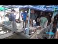 Forecast Mekong: Virtual River of Life
 Living with Fire: Location Factors
 CEOS Future Data Access & Architecture Strategy
 Colombia–USA Bi-national Exchange
 Monitoring Suspended Sediment and Flow along the Mississippi River: Episode 1
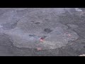 February 14, 2023 — Continued lava lake activity at Kīlauea summit
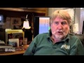 Living with Fire: Fire Decision Model
 Every Pixel - Ground Stations
 I Am A...Wildlife Biologist
 Lake Powell Water Quality Samples at a Specific Depth
 Landsat in Action - Changing Forest Phenology with Andrew Elmore
 Peligros Costeros de Puerto Rico
 Earth Observation User Case Study: Nikki Tulley - Speaking a New Language of Landsat
 A USGS guide for finding and interpreting high-water marks
 Channel Islands: Harnessing Fog on Santa Rosa Island
 Local Travel Time Tomography in the Central U.S.
 What makes a wetland a wetland? (Part 1)
 Vent that formed on the wall of Halema‘uma‘u crater, Kīlauea volcano — June 7, 2023