An overview of landslide hazards in Idaho
Landslides are a significant hazard in Idaho because they are widespread, destructive, disruptive, and their exact timing and location is unpredictable. Despite the drastic precipitation gradient across Idaho, landslides occur throughout the state. Idaho’s underlying geology and steep topography create favorable conditions for landsliding. Furthermore, the location of many of Idaho’s transportation corridors within narrow, steep-sided canyons compounds the threat by exposing critical infrastructure to these landslide hazards. I present examples of several landslides and discuss the Idaho Geological Survey’s efforts to document and study landslide hazards in the state.
Lifton Z (2022) An overview of landslide hazards in Idaho, 14 April 2022.
Video thumbnail used with permission from Zach Lifton, Idaho Geological Survey.
Video: https://www.usgs.gov/media/videos/overview-landslide-hazards-idaho
Видео An overview of landslide hazards in Idaho канала USGS Presentations
Показать
Комментарии отсутствуют
Информация о видео
Другие видео канала
 Global Change Monitoring Portal: Pilot for the Southeast US
 Climate Change and Migratory Species Presentation (Jan 2009) -- Part 1 of 3
 High Resolution Climate Models to Benefit Avian Conservation
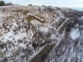 North Dakota landslide mapping: A complete inventory and mapping into the future
 PubTalk-01/2024: Ancient human footprints in North America during the Last Glacial Maximum
 PubTalk-09/2023 - Geothermal Energy Research: Goldilocks to Electricity With Earthquakes in Between
 Climate, Water Quality, Toxic Blooms of Golden Alga in Texas
 2017 October Evening Public Lecture — Global Trends in Mineral Commodity Supplies
 November Evening Public Lecture -- Waterbirds in a Changing Landscape
 Potential Corrosivity of Untreated Groundwater in the United States (Public Lecture)
 NextGen Water Data Update: Monitoring Location Pages & WaterAlert
 WaterML2 Part 3: Surface Hydrology Features Conceptual Model and the Mainstems Logistical Data Model
 Global rainfall thresholds for urban landslides
 The building and upkeep of landslide hazards program: Blue Ridge perspective on a national challenge
 USACE Huntington Use of USGS Data and Services
 topoBuilder: OnDemand, Custom, Topographic Maps
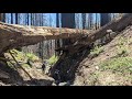 Post-fire debris flows in relation to observed rainfall anomalies: Dolan Fire, California
 Use of UASs (“Drones”) in 2018 at Kīlauea and Beyond
 Climate Change, Mountain Pine Beetles, and Whitebark Pine
 Preparing for landslide disasters: Lessons learned from 20 years of USGS landslide response
 Wildlife Responses to Climate Change Presentation (Jan 2009) -- Part 2 of 3