Merge different raster tiles/ MOSAIC a raster dataset using ArcGIS (Creating a seamless DEM )
How to download ASTER DEM from NASA for free - https://www.youtube.com/watch?v=roryIlOEWlI&t=109s
This tutorial shows you how to combine/ merge different DEM tiles using ArcGIS. In this tutorial you will see how to merge 7 different DEM tiles and create a seamless raster (MOSAIC)
⭐NOTE:
‘Kite’ is an excellent tool that can help you boost your productivity when it comes to programming with its free Artificial Intelligence (AI) powered coding assistant. Kite is a plugin which provides smart completions and documentation as you’re typing-in your code, and its compatible with most of the well-known IDEs such as PyCharm, Spyder and VS Code. I absolutely love it, and recommend you guys to try it out as well.
https://www.kite.com/get-kite/?utm_medium=referral&utm_source=youtube&utm_campaign=geodelta&utm_content=description-only
Видео Merge different raster tiles/ MOSAIC a raster dataset using ArcGIS (Creating a seamless DEM ) канала GeoDelta Labs
Показать
Комментарии отсутствуют
Информация о видео
Другие видео канала

 mosaic raster file :how to merge raster data: merge dem data
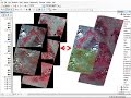 mosaic raster dataset Landsat ArcGis
 Extracting Elevation Data from Google Earth
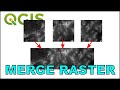 Merge Raster Layers in QGIS (Create a Raster Mosaic)
 Arcgis : Merge the raster datasets /fusionner raster arcgis /Mosaic raster dataset ArcGIS
 Erdas Imagine: Layerstack and Mosaic Tools
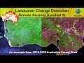 Landcover Change Detection using Landsat 8 (Australian Forest Fires 2019-2020)
 Landslide susceptibility mapping using MCDM and ML approaches Part 1
 How to Mosaic or combine or merge raster datasets- DEM or Satellite images using ArcGIS
 How to Convert Google Earth KMZ file to Shapefile (Quick and Easy)
 Downloading Digital Elevation Data (SRTM) from USGS EarthExplorer
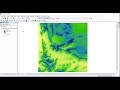 Watershed Delineation using ArcGIS from DEM - Simple and Straightforward
 How to Mosaic or Merge Raster Datasets | Remove Background value | Mosaic satellite images in ArcGIS
 Mosaic or Combine Multiple Raster Datasets - DEM or Satellite Imagery Using ArcGIS
 Stream Order from a Digital Elevation Model (DEM) using ArcGIS
 How to use a DEM to delineate a Watershed/Basin in ArcGIS
 Landsat 8 Image Classification with ArcGIS (Supervised)
 How to Merge different Shapefiles in GIS (Very Easy Method)