Super Typhoon Rolly ( Goni ) Live Updates | Earth’s strongest storm of the year
Super Typhoon Rolly Updates ( Goni ) Goni Update Top Video
Typhoon "Rolly"
Tropical Cyclone: WARNING
Issued at 05:00 pm, 31 October 2020
(Valid for broadcast until the next advisory to be issued at 8 PM today.)
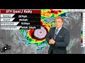
TYPHOON "ROLLY" CONTINUES TO MAINTAIN ITS STRENGTH AS IT MOVES TOWARDS BICOL REGION.
Track and intensity outlook:
Track: On the forecast track, the center of the eye of the typhoon is forecast to pass over Catanduanes - mainland Camarines Provinces area tomorrow morning, and over mainland Quezon tomorrow afternoon. Violent winds and intense rainfall associated with the inner rainband-eyewall region will be experienced over Catanduanes, Camarines Provinces tomorrow early morning through afternoon and over Quezon tomorrow afternoon through evening. After crossing the Southern Luzon - Metro Manila area, the center of "ROLLY" is forecast to exit the mainland Luzon landmass on Monday early morning.
Intensity: "ROLLY" is likely to remain a typhoon category (185-205 km/h) by the time it makes landfall. While traversing over Luzon, "ROLLY" is forecast to weaken considerably and emerge as a severe tropical storm or minimal typhoon over the West Philippine Sea.
Hazards affecting land areas:
Rainfall: Today, the outer rainbands of "ROLLY" will bring light to moderate with at times heavy rains over Bicol Region and Eastern Visayas. Beginning tomorrow early morning, the passage of Typhoon "ROLLY" will bring heavy to intense rains over Metro Manila, Bicol Region, CALABARZON, Aurora, Bulacan, Zambales, Bataan, Marinduque, Romblon, Occidental Mindoro, and Oriental Mindoro. Moderate to heavy rains with at times intense rains (especially the eastern sections of Northern and Central Luzon) will be experienced over Cagayan Valley, Cordillera Administrative Region, Ilocos Region, and the rest of Central Luzon. Flooding (including flash floods), rain-induced landslides, and sediment-laden streamflows (i.e. lahar) may occur during heavy or prolonged rainfall especially in areas that are highly or very highly susceptible to these hazards. PAGASA Regional Services Divisions may issue local thunderstorm/rainfall advisories and heavy rainfall warnings as appropriate.
Strong winds: Destructive typhoon-force winds will be experienced in areas under Tropical Cyclone Wind Signals (TCWS) #3, damaging gale- to storm-force winds in areas under TCWS #2, and strong breeze to near gale conditions in areas under TCWS #1. Based on the intensity forecast, the highest possible wind signal to be raised will be TCWS #4 (for very destructive typhoon-force winds). Potential impacts of the wind conditions to structures and vegetation under each wind signal are detailed in the TCWS section of this bulletin. Elsewhere, strong breeze to near gale conditions due to the northeasterlies will be experienced over Batanes, Babuyan Islands, Ilocos Norte, Apayao, and the coastal and mountainous areas of Cagayan and Isabela (that are not under TCWS #1).
Storm surge: There is a high risk of storm surge of more than 3.0 m over the northern coastal areas of Quezon including Polillo Islands, Camarines Provinces, and Catanduanes; 2.1 to 3.0 m over the coastal areas of Manila, Cavite, Bulacan, Pampanga, Bataan, the southeastern coastal area of Batangas and the southwestern coastal area of Quezon; 1.0 to 2.0 m over the coastal areas of Aurora, Zambales, Occidental Mindoro, the rest of the coastal areas of Bicol Region, Batangas, and Quezon in the next 24 hours which may result in life-threatening and damaging coastal inundation. This storm surge may be accompanied by swells and breaking waves reaching the coast. For more information, please refer to Storm Surge Warning #1 issued at 2PM today posted on PAGASA’s official website.
Hazards affecting coastal waters:
Today, rough to phenomenal seas (2.5 to 15.0 m) will be experienced over the seaboard of areas where TCWS is in effect and rough to very rough seas (2.5 to 5.0 m) over the remaining seaboards of Northern Luzon and the eastern seaboards of Eastern Visayas (that are not under TCWS) and Caraga. Sea travel is risky for all types of seacrafts over these waters, especially those under TCWS.
At 4:00 PM today, the center of Tropical Depression "ATSANI" was estimated at 1,520 km East of Southern Luzon (14.3 °N, 138.3 °E). It currently has maximum sustained winds of 55 km/h near the center and gustiness of up to 70 km/h. It is moving northwestward at 25 km/h and is forecast to enter the Philippine Area of Responsibility tomorrow afternoon. However, it remains less likely to affect any portion of the country over the next 2 to 3 days. It is likely to re-intensify into a tropical storm in the next 24 hours.
Видео Super Typhoon Rolly ( Goni ) Live Updates | Earth’s strongest storm of the year канала Jccastro TV14
Typhoon "Rolly"
Tropical Cyclone: WARNING
Issued at 05:00 pm, 31 October 2020
(Valid for broadcast until the next advisory to be issued at 8 PM today.)
TYPHOON "ROLLY" CONTINUES TO MAINTAIN ITS STRENGTH AS IT MOVES TOWARDS BICOL REGION.
Track and intensity outlook:
Track: On the forecast track, the center of the eye of the typhoon is forecast to pass over Catanduanes - mainland Camarines Provinces area tomorrow morning, and over mainland Quezon tomorrow afternoon. Violent winds and intense rainfall associated with the inner rainband-eyewall region will be experienced over Catanduanes, Camarines Provinces tomorrow early morning through afternoon and over Quezon tomorrow afternoon through evening. After crossing the Southern Luzon - Metro Manila area, the center of "ROLLY" is forecast to exit the mainland Luzon landmass on Monday early morning.
Intensity: "ROLLY" is likely to remain a typhoon category (185-205 km/h) by the time it makes landfall. While traversing over Luzon, "ROLLY" is forecast to weaken considerably and emerge as a severe tropical storm or minimal typhoon over the West Philippine Sea.
Hazards affecting land areas:
Rainfall: Today, the outer rainbands of "ROLLY" will bring light to moderate with at times heavy rains over Bicol Region and Eastern Visayas. Beginning tomorrow early morning, the passage of Typhoon "ROLLY" will bring heavy to intense rains over Metro Manila, Bicol Region, CALABARZON, Aurora, Bulacan, Zambales, Bataan, Marinduque, Romblon, Occidental Mindoro, and Oriental Mindoro. Moderate to heavy rains with at times intense rains (especially the eastern sections of Northern and Central Luzon) will be experienced over Cagayan Valley, Cordillera Administrative Region, Ilocos Region, and the rest of Central Luzon. Flooding (including flash floods), rain-induced landslides, and sediment-laden streamflows (i.e. lahar) may occur during heavy or prolonged rainfall especially in areas that are highly or very highly susceptible to these hazards. PAGASA Regional Services Divisions may issue local thunderstorm/rainfall advisories and heavy rainfall warnings as appropriate.
Strong winds: Destructive typhoon-force winds will be experienced in areas under Tropical Cyclone Wind Signals (TCWS) #3, damaging gale- to storm-force winds in areas under TCWS #2, and strong breeze to near gale conditions in areas under TCWS #1. Based on the intensity forecast, the highest possible wind signal to be raised will be TCWS #4 (for very destructive typhoon-force winds). Potential impacts of the wind conditions to structures and vegetation under each wind signal are detailed in the TCWS section of this bulletin. Elsewhere, strong breeze to near gale conditions due to the northeasterlies will be experienced over Batanes, Babuyan Islands, Ilocos Norte, Apayao, and the coastal and mountainous areas of Cagayan and Isabela (that are not under TCWS #1).
Storm surge: There is a high risk of storm surge of more than 3.0 m over the northern coastal areas of Quezon including Polillo Islands, Camarines Provinces, and Catanduanes; 2.1 to 3.0 m over the coastal areas of Manila, Cavite, Bulacan, Pampanga, Bataan, the southeastern coastal area of Batangas and the southwestern coastal area of Quezon; 1.0 to 2.0 m over the coastal areas of Aurora, Zambales, Occidental Mindoro, the rest of the coastal areas of Bicol Region, Batangas, and Quezon in the next 24 hours which may result in life-threatening and damaging coastal inundation. This storm surge may be accompanied by swells and breaking waves reaching the coast. For more information, please refer to Storm Surge Warning #1 issued at 2PM today posted on PAGASA’s official website.
Hazards affecting coastal waters:
Today, rough to phenomenal seas (2.5 to 15.0 m) will be experienced over the seaboard of areas where TCWS is in effect and rough to very rough seas (2.5 to 5.0 m) over the remaining seaboards of Northern Luzon and the eastern seaboards of Eastern Visayas (that are not under TCWS) and Caraga. Sea travel is risky for all types of seacrafts over these waters, especially those under TCWS.
At 4:00 PM today, the center of Tropical Depression "ATSANI" was estimated at 1,520 km East of Southern Luzon (14.3 °N, 138.3 °E). It currently has maximum sustained winds of 55 km/h near the center and gustiness of up to 70 km/h. It is moving northwestward at 25 km/h and is forecast to enter the Philippine Area of Responsibility tomorrow afternoon. However, it remains less likely to affect any portion of the country over the next 2 to 3 days. It is likely to re-intensify into a tropical storm in the next 24 hours.
Видео Super Typhoon Rolly ( Goni ) Live Updates | Earth’s strongest storm of the year канала Jccastro TV14
Показать
Комментарии отсутствуют
Информация о видео
Другие видео канала
 Super Typhoon Goni / Rolly Strongest Storm of 2020, Landfall Possible Near Manila
 15 Unbelievable Places that Actually Exist
![[LIVE] Tracking Typhoon Rolly (Bagyong Rolly) & TS Atsani (Siony) + Updates from PAGASA October 31](https://i.ytimg.com/vi/T5j6Tf_P1vs/default.jpg) [LIVE] Tracking Typhoon Rolly (Bagyong Rolly) & TS Atsani (Siony) + Updates from PAGASA October 31
[LIVE] Tracking Typhoon Rolly (Bagyong Rolly) & TS Atsani (Siony) + Updates from PAGASA October 31 Goni (#RollyPH) A Category 5 Super Typhoon Approaching the Philippines
 Weather Update | October 31 2020 | Bagyong Rolly (Super Typhoon Goni)
 ‘Rolly’ may pass close to Metro Manila after Quezon landfall Sunday
 Catanduanes placed under signal no. 3 as typhoon Rolly approaches land | ANC
 24 Oras News Alert - 02:43 PM | October 31, 2020
 Bagyong Rolly: nag uumpisa ng maramdaman sa Isla ng Catanduanes
 Typhoon Rolly (GONI) & Tropical Storm ATSANI (Siony) Updates from PAGASA 11 AM Bulletin October 31
 New: Mars In 4K
 Why Planes Don't Fly Over the Pacific Ocean
 Ships in Horrible Storms
 Typhoon Goni (#RollyPH) Rapidly Intensifying - Live Update
 *CLOSE RANGE* The Dalton/Ashby, MN EF4 Tornado - Full Chase and Life Cycle - July 8th, 2020
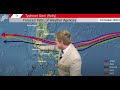 Typhoon Goni (Rolly) Explodes in intensity. Atsani continues to develop. 30 October Update
 The 10 Best Places To Live In Florida (USA) - Job, Family, and Retire
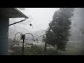 Cedar Rapids Derecho Live Camera Aug 10, 2020
 Super Typhoon Haiyan: Inside the Belly of the Beast
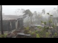 Exact footage of Typhoon Yolanda at Roxas City, Philippines