Custom Maps using SAS Planet and Insight Map Creator for B&G, Lowrance, SIMRAD chartplotters
Learn how to create your own satellite maps for safer cruising around coral reefs with much better detail than the purchased proprietary charts.
Full instructions on how to download satellite imagery and create your own maps using SAS Planet and Insight Map Creator.
Tools used and links for downloading
SAS Planet
http://sasgis.org/download
Insight Map Creator
http://gofreemarine.com/developers/insight-map-creator/
Видео Custom Maps using SAS Planet and Insight Map Creator for B&G, Lowrance, SIMRAD chartplotters канала Sailing SV No Regrets
Показать
Комментарии отсутствуют
Информация о видео
Другие видео канала
 download very hight resolution satellite image tif from SASPLANET
 TUTO OpenCPN : Découverte des options de OPENCPN
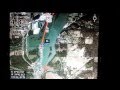 Make your own maps for Lowrance HDS
 Sonar for Dummies! Fish Finder Explained for BEGINNERS! FIRST 6 LESSONS TOGETHER IN ONE PLACE.
 How To Use SAS Planet
 Как настроить GENESIS LIVE с нуля | Красивая палитра и загрузка карт C-MAP | LOWRANCE HDS LIVE/TI2
 Convert Google Earth Placemarks to Lowrance Waypoints
 Boat Navigation on the Cheap Using a Tablet and Navionics - Ep. 2
 ПРАВИЛЬНАЯ НАСТРОЙКА SAS.ПЛАНЕТА v.200606
 Tutoriel SAS Planet: comment créer des cartes marines avec des images satellites et autres
 How to download Satellite Images from the USGS, ESA and Google Earth Engine
 B&G Vulcan Sailing Chartplotters with SailSteer - Get all your sailing info on a single screen.
 how to download Google Earth images very high resolution using Sasplanet
 Создание карты глубин GenesisLive. Наложение на спутник. Добавление берегов GenesisLive.
 ACTIVE TARGET: The Bridge Beat Down
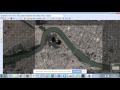 SAS PLANET how to download satellite images free
 How to Download Free Trail Maps on Garmin GPS
 Beginner tips for Gaia GPS (Overlanding & Apple Car Play)
 Настройки эхолота Lowrance hook reveal 7 hdi и поведение на воде.
 Боковой обзор эхолота или смотрим под воду с Lowrance StructureScan (Elite Ti Carbon HDS Live)