How-to: Extracting Building Footprints using Esri's Deep Learning Model
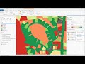
In this video, learn how to use Esri's Building Footprint Extraction deep learning model with ArcGIS Pro. This deep learning model is used to extract building footprints from high resolution satellite imagery. While its designed to work optimum in the subcontinent United States, it is seen to perform beautifully in other part of the globe as well. The resultant building footprint layers are useful in preparing base maps and analysis workflows for urban planning and development, insurance, taxation, change detection, infrastructure planning and a variety of other applications.
This model is accessible for anyone with an ArcGIS Online subscription at no additional cost.
Download the model: https://go.esri.com/building-footprint-download-model-yt
See results: https://go.esri.com/building-footprint-deep-learning-model-yt-see-results
---------------------------------------------------------------------------------------------------
Follow us on Social Media!
Twitter: https://twitter.com/Esri
Facebook: https://facebook.com/EsriGIS
LinkedIn: https://www.linkedin.com/company/esri
Instagram: https://www.instagram.com/esrigram
The Science of Where: http://www.esri.com
Видео How-to: Extracting Building Footprints using Esri's Deep Learning Model канала ArcGIS
Показать
Комментарии отсутствуют
Информация о видео
Другие видео канала
 ArcGIS Pro: Machine Learning Classification for Impervious Surfaces
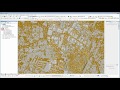 LiDAR Building Extraction Tool Tutorial (Full Video)
 Accurate Geospatial Intelligence from Drone Imagery with Esri & DJI
 Applying Spatial Statistics: The Analysis Process in Action
 How to create a 3D Terrain with Google Maps and height maps in Photoshop - 3D Map Generator Terrain
 Esri - Smithsonian StoryMaps Webinar
 Integrating Deep Learning with ArcGIS using Python
 ArcGIS User Seminar - Virtual - Baltimore and New York City
 Building Footprint Imagery Detection With EOfactory
 Automated Object Based Image Feature Extraction
 ArcGIS Pro: Image Segmentation, Classification and Machine Learning
 Extracting and visualising Roof Data in QGIS
 What's New in ArcGIS Pro 2.6
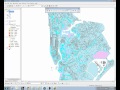 GIS Video Tutorial #1
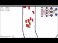 Deep Learning Cars
 A Quick Tour of Esri's Online Classroom
 Using the Community Maps Contributor App
 ArcGIS Velocity: Design a Real-time Analytic
 Webinar: 3D Planning with SketchUp and CityEngine