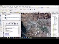
Composite Sentinel 2 bands Data using ArcGIS R10 m
How to Composite Sentinel 2 bands Data using ArcGIS
In general it is possible to make the combinations that our imagination allows, but it is also necessary to know the details of each band.
how to Download Sentinel 2 Datasets 2020 for Free: https://www.youtube.com/watch?v=oly4Jkx5LW0
Видео Composite Sentinel 2 bands Data using ArcGIS R10 m канала Made 4 Geek
Показать
Комментарии отсутствуют
Информация о видео
Другие видео канала
 Downloading and preprocessing Sentinel 2 images using the Semi-Classification Plugin in QGIS 3.0
 NASA ARSET: Conducting a Change Detection Analysis, Session 2/2
 Calculate NDVI from Sentinel 2A in ArcGIS
 Landsat 8 Image Classification with ArcGIS (Supervised)
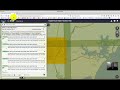 Downloading Sentinel Imagery Via Copernicus Open Access Hub
 how to Reclassify and Convert Raster Image to Polygone Shapefile using ArcGIS
 Supervised Classification of Sentinel-2 Images
 SNAP - installation and configuration
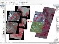 mosaic raster dataset Landsat ArcGis
 Create TIN, DEM and Slope from Contour Line by ArcGIS
 How to Composite bands sentinel2 in Arcgis 10.5
 How to Georeference an Image or a Scanned Map using ArcMap
 Reclassify & Convert Raster to Shapefile ( Polygon) & Calculate Area Using ArcGIS
 Remote Sensing #18 - ENVI Sentinel 2, download, georeference, layer stack
 Calculate NDVI from Sentinel 2 and reclassify in QGIS
 Land use Map for SWAT Model- Maximum Likelihood Classification ENVI
 How to calculate normalized burn ratio (NBR) in QGIS
 how to Download Sentinel 2 Datasets 2020 for Free
 Downloading Landsat 8 satellite image data to use in a GIS
 Landsat 8 Image Classification using QGIS