NDVI | Vegetation/Forest Cover Map in ArcGIS
How to NDVI in arcGIS. Hope you will learn easily how to do NDVI for your study area.
The Normalized Difference Vegetation Index (NDVI) is constructed from the Red band (R) and near infra-red (PIR). NDVI is used to quantify vegetation greenness and is useful in understanding vegetation density and assessing changes in plant health.
The Standardized Vegetation Index emphasizes the difference between the visible band of Red and that of the near infrared.
NDVI Calculation Equation:
NDVI=(PIR-R)/(PIR+R)
In Landsat 8,
NDVI=(B5-B4)/(B5+B4)
In Landsat 4-7,
NDVI=(B4-B3)/(B4+B3)
Our others important Tutorial:
How to Cut/Extract Study Area/AOI from Satellite Image and Shapefile: https://www.youtube.com/watch?v=JMGvmDeW1-0&t=7s
Download Satellite Image from USGS website: https://www.youtube.com/watch?v=v-I3waJid4s
How to Download GIS Shapefile of any Country for free: https://www.youtube.com/watch?v=gJZ5FWG6jHM&t=55s
Download update Shapefile (GIS) of any Area: https://www.youtube.com/watch?v=ka_7nT06iT0&t=25s
How to prepare Study Area Map in ArcGIS: https://www.youtube.com/watch?v=kFpAavw0lMs
Download Google Earth Image and Land Cover Classification: https://www.youtube.com/watch?v=BrpatJojnsg&t=9s
How to Create DEM and Contour by Google Earth & ArcGIS: https://www.youtube.com/watch?v=GA3TIpcrLjM&t=37s
Band Composite and Extraction of AOI from Satellite Imagery using ArcGIS: https://www.youtube.com/watch?v=SiRZCYqV2RY&t=14s
Georeferencing JPEG/JPG Image Map or Scanned Map in ArcGIS: https://www.youtube.com/watch?v=DDR_pjca4lw&t=14s
SAS PLANET very High Resolution free Google earth Image: https://www.youtube.com/watch?v=IbfjVGTi2sA&t=12s
Easy way to Calculate Area, Perimeter and Length in ArcGIS: https://www.youtube.com/watch?v=NQDYsgNk9po&t=3s
Music Credit:
This Feeling - Atch https://soundcloud.com/atch-music
Creative Commons — Attribution 3.0 Unported — CC BY 3.0
Free Download / Stream: https://bit.ly/atch-this-feeling
Music promoted by Audio Library https://youtu.be/6c-QjUUOUEE
Related tags: NDVI, How to NDVI, NDVI in arcGIS, NDVI map, Normalized Difference Vegetation Index (NDVI), How to NDVI in arcGIS, How to NDVI in GIS, NDVI for study area
If you want to learn GIS and Remote sensing in easy way, you can Subscribe my YouTube channel. I am trying to make easy tutorials for beginners. I’m on the way to prepare more essential tutorials for you.
Видео NDVI | Vegetation/Forest Cover Map in ArcGIS канала GIS & RS Solution
Показать
Комментарии отсутствуют
Информация о видео
Другие видео канала
 Landsat 8 Image Classification with ArcGIS (Supervised)
 Correlation with NDVI and LST using ArcGIS and Excel
 Normalized Difference Vegetation Index NDVI Geogrphic informations system ARCGIS - ESRI - GIS
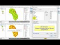 How to Calculate Stream or drainage Length and Density in ArcGIS
 Convert NDVI raster to NDVI shapefile using ArcGIS
 An Introduction to how ArcGIS can help you manage your forest data
 Study Area Mapping | Create Map Layout in ArcGIS
 ArcScene 3D Maps
 River Stream Order Map in ArcGIS | ArcGIS Tutorial 28
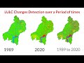 Land use/Land cover Change detection Analysis for a Area over a certain timeline like 1989 to 2020
 NDVI in ArcGIS
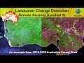 Landcover Change Detection using Landsat 8 (Australian Forest Fires 2019-2020)
 Downloading Landsat 8 OLI Data and Computing NDVI in ArcGIS Pro
 Landsat 8 Image Classification using QGIS
 Download Google Earth Image and Land Cover Classification in ArcGIS || Supervised and Unsupervised
 #2 HWSD Global Soil Mapping Units🔥🔥🔥🔥 in ArcGIS by Geospatial Solutions
 Joining Census Data to a Shapefile in ArcGIS (Table Join)
 Normalized difference vegetation index (NDVI) by Google Earth Engine.
 Enhance Vegitation Index ( EVI )
 How To Add a Locator Map in ArcGis