Calculate NDVI with QGIS v3.4
The NDVI (Normalized Difference Vegetation Index) is a versatile vegetation index to evaluate the vegetation and dynamic of the vegetation coverage change. This index has been studied and evaluated with many satellites over the years, changing its calculus method in relation to the number and type of bands of the satellite. This video shows how to apply the NDVI to Landsat-8 images using QGIS.
Landsat-8 Operational Land Imager (OLI) and Thermal Infrared Sensor (TIRS) images consist of nine spectral bands with a spatial resolution of 30 meters for Bands 1 to 7 and 9. The ultra blue Band 1 is useful for coastal and aerosol studies. Band 9 is useful for cirrus cloud detection. The resolution for Band 8 (panchromatic) is 15 meters. Thermal bands 10 and 11 are useful in providing more accurate surface temperatures and are collected at 100 meters.
References:
https://www.qgis.org/en/site/
https://libra.developmentseed.org/
https://landsat.usgs.gov/what-are-band-designations-landsat-satellites
Видео Calculate NDVI with QGIS v3.4 канала Alfredo Bencomo
Показать
Комментарии отсутствуют
Информация о видео
Другие видео канала
 QGIS NDVI Analysis with Sentinel-2 Imagery
 Landsat 8 Image Classification using QGIS
 NDVI - Normalized Difference Vegetation Index
 An Absolute Beginner's Guide to QGIS 3
 QGIS 3 - № 12. - Индексы вегетации NDVI, RVI, SVI ,Вычисление, применение,эксперимент.
 Cálculo del Indice de Vegetación NDVI de Imágenes Landsat 8 con QGIS
 Vegetation and Biomass Indices Estimation with QGIS 3 - Tutorial
 Tutorial QGIS 5.2 - Cálculo de NDVI
 Land Cover Classification using the Semi-Automatic Classification Plugin version 7
 QGIS User0014 - Multi Spectral Imagery
 Clipping Raster (DEM) by a Polygon in QGIS
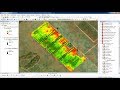 how to calculate NDVI using ArcGis
 QGIS 3 for Absolute Beginners
 Charger des cartes Sentinel-2 (Copernicus) sous QGIS puis calculer indice de végétation NDVI
 How to Calculate NDVI Using Landsat 8 Images and QGIS
 Landsat 8 NDVI calculation using ArcGIS 10.2 raster calculator
 Basic tutorial 1: Land Cover Classification of Landsat Images
 Come calcolare l'indice NDVI in QGIS | Tutorial GIS
 NDVI no QGIS - simples e rápido
 Data Cube Application Library (DCAL) - NDVI Phenology