Landsat 7 Composite Band Combinations
#Seekshow #Subscribe
Image analysis is very important in Remote Sensing. When you are using satellite images you will have to apply different color combinations to easily detect the land features. So watch this video to have an idea about Landsat 7 Satellite image True color( Natural Color) and False color combinations and more.
In this Channel I am talking a lot about these kind of educational and technology, Tips & Tricks, Motivational, Tutorial stuff. If you interested in watching more videos make sure to subscribe to my YouTube channel.
Landsat 8 Composite Bands - https://www.youtube.com/watch?v=IdFzdhwFzxw&t=5s
Sentinal 2A Composite Bands - https://www.youtube.com/watch?v=x56hc9IIOD4&t=1s
==For More Education==
Imagery and GIS: Best Practices for Extracting Information from Imagery: https://amzn.to/3e8WePF
Very High Resolution (VHR) Satellite Imagery: https://amzn.to/30QwG66
Remote Sensing Time Series Image Processing (Imaging Science): https://amzn.to/30IsTb7
Thanks For Watching 👀
Don't Forget To Like And S U B S CR I B E for Seek Show - https://bit.ly/2Ra4xCM
°°°°°°°°°°°°°°°°°°°°°°°°°°^^^^^^^^^^^^^°°°°°°°°°°°°°°°°°°°
Check Below Playlists For More Videos in My Channel ⤵️
👉 Let's Learn ArcGIS - https://www.youtube.com/watch?v=V041aLRXEeE&list=PLnC1dq66hZqHYGGaM9w-fmfc4KkFQQgOF
👉 Tech Track Show - https://www.youtube.com/watch?v=hzfG9RPwZEk&list=PLnC1dq66hZqGZkXTvtlP30aPgVHIjyJQu
👉 Best Android Games - https://www.youtube.com/watch?v=EA8ixf7l5jY&list=PLnC1dq66hZqHgKsFeEVE0yTtTcmOwf-PK
👉 Around Sri Lanka - https://www.youtube.com/watch?v=v3f6MNoPZ4k&list=PLnC1dq66hZqEVGbWOQXxXnYjDn2aimbwK
👉 Motivational - https://www.youtube.com/playlist?list=PLnC1dq66hZqH2CAgvmd5WEfOWd-38seqV
°°°°°°°If you found this video valuable°°°°°°°
Hit Like 👍
Share 🤲
Comment 🗣 .
--Follow & Join ‼️ --
✅ Instagram - https://www.instagram.com/seek_show/
✅ Twitter - https://twitter.com/Seek_Show
✅ Facebook - https://www.facebook.com/seekshowleenath/
💟 🤫💯 Personal Instagram - https://www.instagram.com/wymukthi_srilankanlifenotes/
✅ For Sponsorships & Offers - leenath91gamage0707@gmail.com
Contact me here if you need my ArcGIS Mapping Services
Get upto 100$ - Register and buy - http://www.fiverr.com/s2/ceccb2c3c3
,
1. To Design Professional Maps For You Data - https://www.fiverr.com/leenathwymkthi/design-professional-maps-for-you-data
2. To Do Any Custom Gis Work Accurately - https://www.fiverr.com/leenathwymkthi/do-any-custom-gis-work-accurately
3. To Create Professional Maps For Your Data - https://www.fiverr.com/leenathwymkthi/digitize-your-image-map-using-arcgis
4. To Design Professional Gis Maps For You - https://www.fiverr.com/leenathwymkthi/design-professional-gis-maps-for-you
Видео Landsat 7 Composite Band Combinations канала Seek Show School
Показать
Комментарии отсутствуют
Информация о видео
Другие видео канала
 Landsat Images - Band combination, Mosaic, Mask and removing black borders - ArcMap
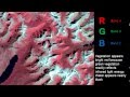 Remote Sensing - Band Combinations
 Landuse classification of Sentinel 2A, L-8 & L-7 image in ArcGIS | A complete guide on LULC
 Fix Landsat 7 Scan Line Error using Landsat Toolbox in ArcMap
 Landsat 8 Image Classification with ArcGIS (Supervised)
 Layer stacking, Remove black background, Fix Landsat 7 scan line error, and cloud removing by ENVI
 Composite Landsat 8 bands
 QGIS Lessons-7 How to create False Color Composite (FCC) Or Band Composite using Landsat 8 Data
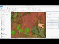 Landsat 8 Band Combinations in ArcGIS Pro
 Change Analysis || Change Detection || Using Unsupervised Classification in ARCMAP Version 10.2.2
![Land use classification using ArcGIS. Landsat 8 image classification [2021]](https://i.ytimg.com/vi/IwsQicKFI-g/default.jpg) Land use classification using ArcGIS. Landsat 8 image classification [2021]
Land use classification using ArcGIS. Landsat 8 image classification [2021] How to Download High Resolution Satellite Image from USGS (Glovis) Portal
 R for Basic Image Processing Part 1| Remote Sensing|Landsat
 How to composite bands in ArcGIS | Pan Sharpening Imagery in ArcMap
 Accuracy Assessment | Kappa Coefficient | User Accuracy| Producer Accuracy| Overall Accuracy
 Download Landsat 8 Satellite Images from Google Earth Engine
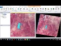 ATMOSPHERIC CORRECTION OF LANDSAT 7 ON ERDAS 2014
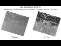 Removing Scan Line Error of Landsat 7 Using ArcGIS Landsat Tools || Landsat Tools||@GeoTech Studio
 Satellite Imagery Clouds Cover Removal in ArcGIS Desktop
 Supervised classification of Landsat Images using the Semi-Automatic Classification Plugin for QGIS