- Популярные видео
- Авто
- Видео-блоги
- ДТП, аварии
- Для маленьких
- Еда, напитки
- Животные
- Закон и право
- Знаменитости
- Игры
- Искусство
- Комедии
- Красота, мода
- Кулинария, рецепты
- Люди
- Мото
- Музыка
- Мультфильмы
- Наука, технологии
- Новости
- Образование
- Политика
- Праздники
- Приколы
- Природа
- Происшествия
- Путешествия
- Развлечения
- Ржач
- Семья
- Сериалы
- Спорт
- Стиль жизни
- ТВ передачи
- Танцы
- Технологии
- Товары
- Ужасы
- Фильмы
- Шоу-бизнес
- Юмор
Van der Aa's 1729 Holy Land Map — Sacred Geography in Copper - Scriptorium
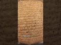
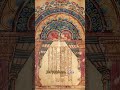
In 1729, Leiden publisher Pieter van der Aa released one of the most ambitious cartographic projects of the early eighteenth century: La Galerie Agréable du Monde, a seventy-volume compendium of global geography. This Holy Land map is one of its most historically layered plates.
Van der Aa worked not as a field surveyor but as a masterful compiler. His Leiden workshop drew on earlier Flemish and French maps, Dutch commercial intelligence networks, and printed pilgrimage accounts to produce copper-engraved plates that were both visually authoritative and commercially appealing. The target audience was the educated Dutch burgher — curious, Protestant, and hungry for encyclopedic knowledge of distant territories.
The Holy Land plate stretches from the Mediterranean littoral east across the Jordan River valley to the Dead Sea. Major biblical sites appear by name: Jerusalem, Jericho, Bethlehem, Nazareth, Capernaum, and Tiberias. Ancient Israelite tribal boundaries — Judah, Benjamin, Ephraim, Manasseh — are rendered alongside Ottoman-era place names, making the map a palimpsest of the region's layered historical occupation across biblical, Roman, Byzantine, Crusader, and Ottoman periods.
For Reformed Protestant readers in northern Europe, this kind of map served a dual function. It confirmed that the events described in the Old and New Testaments happened in real, locatable places. And it offered visual pilgrimage — access to sacred geography without the cost and danger of eastern Mediterranean travel in the eighteenth century.
This single plate holds together historical conviction, commercial publishing ambition, and the Protestant instinct to ground faith in the concrete geography of scripture.
Explore the full Scriptorium archive at https://www.discipleshipuniverse.com/scriptorium
#BiblicalArchaeology #BibleStudy #ChurchHistory #Theology #BiblicalManuscripts #Seminary #Bible #HolyLandMap
Видео Van der Aa's 1729 Holy Land Map — Sacred Geography in Copper - Scriptorium канала Scriptorium
ancient history mercator projection geography why all maps are wrong mercator history channel world maps history documentary world map ptolemy lost knowledge history of cartography graham hancock globe navigation map making bible shorts gall peters map map ancient egypt mapping world map flat why all world maps are wrong border unique geography maps are wrong roman empire the history channel geography education globe maps history channel documentaries
Комментарии отсутствуют
Информация о видео
3 июня 2026 г. 23:00:26
00:01:38
Другие видео канала