Tree Species Identification Through 3D / Hyperspectral Fusion
360 degree fly-through of 3D captured forest. Tree species have been derived through the exploitation of fused Hyperspectral imagery products and point cloud analytics.
For more information, visit: https://quantumspatial.com/our-solutions/forestry
Видео Tree Species Identification Through 3D / Hyperspectral Fusion канала Quantum Spatial
For more information, visit: https://quantumspatial.com/our-solutions/forestry
Видео Tree Species Identification Through 3D / Hyperspectral Fusion канала Quantum Spatial
Показать
Комментарии отсутствуют
Информация о видео
Другие видео канала
 Tree species mapping by combining hyperspectral with LiDAR data
 Aerial LiDAR Analytics for Electric Distribution
 Drone Forest Inventory
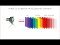 Multispectral Camera Technology
 Precise multispectral forest mapping | Dr. Eugene Lopatin
 The medical applications of Hyperspectral Imaging
 Remote Sensing: Mining for Oil and Gas
 Forestry Applications for Drone Technology facebook.com/ForestryDrones/
 Drone LIDAR Mapping Indonesia Monument, Garuda Wisnu Kencana
 Hyperspectral Imaging: Beyond Limitations of Human Color Vision | Dr. Narine Sarvazyan | TEDxYSMU
 Detecting Plant Diseases Earlier Using Hyperspectral Imaging
 Automated LiDAR Classification and Analytics for Electric Transmission
 Autonomous UAV Flight and Mapping beneath Forest Canopy (high-fidelity simulated and real forests)
 Top 5 BIGGEST Trees on Earth
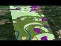 Mapping the Invisible: Introduction to Spectral Remote Sensing
 Data Fusion For Intelligence
 Forest Inventory Using Virtual Reality, Full Tree Assessment Using Ultradense LiDAR
 Showing DEM in 3D View in ArcGIS || DEM in 3D View in ArcMap || DEM in Arcsene
 I spent $180,000 on this LiDAR now DJI released one for $500
 QUT's hyperspectral camera and UAV system at work above Ningaloo Reef