Earth as Art 2
The Earth As Art project began in the early 2000s, and its original intent remains the same: to produce images that do not look like satellite images at first glance.
Earth As Art shows not only what satellites capture in the visible wavelengths of light you and I can see, but also what’s hiding in the invisible wavelengths that Landsat sensors can detect in the infrared part of the electromagnetic spectrum. Those combinations can bring out much more scientific value, but also can produce imagery of breathtaking beauty.
Download these images for free: https://eros.usgs.gov/image-gallery/earth-as-art
View audio described version: https://www.usgs.gov/media/videos/earth-art-2-ad
Video Credit: Benjamin De Groot (Contractor for USGS EROS Center), Video and Animation Specialist
Contact: USGS EROS Center, eroscommunications@usgs.gov
View at USGS page: https://www.usgs.gov/media/videos/earth-art-2
Видео Earth as Art 2 канала USGS
Показать
Комментарии отсутствуют
Информация о видео
Другие видео канала
 EarthShots — Satellite Images of Environmental Change
 Water appears in Halemaʻumaʻu - Kīlauea Volcano
 What Does a USGS Hydrologic Technician Do to Inspect Streamgages?
 Mount St. Helens: May 18, 1980
 Kīlauea Volcano — Lava Scenes From Fissure 8
 What Does a USGS Hydrologic Technician Do
 Lake Mead: Clear and Vital
 Hydropower in Ethiopia
 Largest Gravity Changes Ever Recorded: 2018 Kīlauea Eruption
 Mount St. Helens: A Catalyst for Change
 Volcano Hazard Maps: Past, Present, and Future
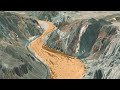 The Mojave River: A 3D Journey
 Status of (mostly) WA Volcanoes: Report to Emergency Managers 2020-21
 Colorado River: Spring Disturbance Flow
 Mitigating Hazards at Cascade Range Volcanoes
 We are the Coastal and Marine Hazards and Resources Program
 Image of the Week - Cold War Craters in Nevada
 The Yellowstone Volcano Observatory: Overview, Monitoring, Hazards, and Noteworthy Results
 USGS Coastal Change Hazards
 Kīlauea Summit Eruption | Lava Returns to Halemaʻumaʻu