Hiking in Switzerland | Col de la Brinta via Crêt du Midi | Swiss Alps Canton Valais | 2020 (4K)
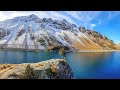
Breathtaking view over the Swiss Alps as we hiked from Crêt du Midi up to Col de la Brinta. Starting at Vercorin we took the gondola up to Crêt du Midi mountain station. There we followed a steep path all the way up to La Brinta. A very challenging alpine trail led us around the summit of La Brinta. We followed the long ridge to Col de la Brinta and finally to the highest point of our hike at Sex de la Brinta. During the entire hike we had a stunning view over the Valais Alps including the famous Matterhorn and the Dom mountain. After lunch break we returned to Col de la Brinta for our descent to the Alp de Tsartsey and further to the high plateau of l’Ar du Tsan. On this plateau the river Rèche created a wonderful moor and on exiting the plain at le Pichiot it turns into a beautiful waterfall. From there we headed back to the Crêt du Midi mountain station where we took the gondola down to Vercorin.
Tour itinerary
After a short gondola ride from Vercorin the tour starts at the Crêt du Midi mountain station (2332m). From there a steep alpine trail climbs up to La Brinta (2659). The way around the summit is very challenging and requires good hiking skills. Soon after we reach Col de la Brinta (2600m) where the path diverts down into the valley. We continue walking on the ridge and arrive at the highest point at Sex de la Brinta (2693m). We return via the same path to Col de la Brinta and descend to the Alp de Tsartsey (2230m). From there we continue to the high plateau of l’Ar du Tsan (2183m) and the waterfall at le Pichioc (2182m). Finally we return to Crêt du Midi mountain station and take the gondola back down to Vercorin.
Tour date: September 13, 2020
Distance: 11,3 km
Duration: 4h 20min
Elevation: 751m up/down 751m
Difficulty: medium
Links to hiking website and map
~~~~~~~~~~~~~~~~~~~~~~~~~
Schweizmobil.ch
Tour description (similar tour but without La Brinta)
https://www.schweizmobil.ch/de/wanderland/routen/route-0217.html
Map
https://map.schweizmobil.ch/?lang=de&photos=yes&logo=yes&season=summer&bgLayer=pk&resolution=5.56&E=2607272&N=1118750&trackId=1668335262
~~~~~~~~~~~~~~~~~~~~~~~~~~~~~~~~~~~
#hiking #switzerland #swissalps #mountains #nature
Видео Hiking in Switzerland | Col de la Brinta via Crêt du Midi | Swiss Alps Canton Valais | 2020 (4K) канала Sandra & Markus Trachsel
Показать
Комментарии отсутствуют
Информация о видео
7 октября 2020 г. 23:30:00
00:19:30
Другие видео канала
 Hiking in Switzerland | Lac de Cleuson and Bisse de Chervé | Swiss Alps Canton Valais | 2020 (4K)
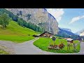 Lauterbrunnen, Switzerland's most beautiful Village
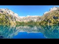 Hiking in Switzerland | Grand Bisse d'Ayent via Lac de Tseuzier | Swiss Alps Canton Valais | 2020 4K
 Hiking in Switzerland | Gemmenalphorn via Niederhorn with Ibex | Swiss Alps Canton Bern | 2020 (4K)
 Paragliding above Weisshorn and Dent Blanche - Cret du Midi
 Hiking 90 Miles Alone in Picos de Europa Spain
 Hiking in Switzerland | Dent de Nendaz via Balavaux | Swiss Alps Canton Valais | 2020 (4K-Video)
 Top 10 Places To Visit In The Alps
 Hiking in Switzerland | Le Grammont to Alamont | Swiss Alps Canton Valais | 2020 (4K-Video)
 Hiking 120 Miles Alone on the Tour Du Mont Blanc Loop
 Hiking in Switzerland | Lac Bleu via Zau des Têtes | Swiss Alps Canton Valais | 2020 (4K-Video)
 Norway AMAZING Beautiful Nature with Relaxing Music and sound, 4k Ultra HD | Relaxation film
 Der größte Wasserfall in Europa: Krimmler Wasserfälle (385 m) in Österreich
 The Swiss Alps: Wild Animal Paradise | Free Documentary Nature
 Vols biplaces au Crêt-du-Midi
 Amazing Safari in Lewa Wildlife Conservancy | Kenya 2020 | 4K-Video
 World's Most Beautiful Railway - The Bernina Express
 Everest - The Summit Climb
 Wanderung Rofflaschlucht mit "begehbarem" Wasserfall (Graubünden / Schweiz)
 4K Splendors of Switzerland, 4K Video Ultra HD With Relaxing Music