Cloud Compare 11: Change Detection analysis
This video shows how to conduct a change detection analysis between two point clouds using two techniques: (1) the Cloud-to-Cloud distance (C2CD) and (2) Multi-scale Model to Model Cloud Comparison (M3C2).This is a very useful method to study aspects such as land cover changes, urban development, erosion, flooding, sedimentation and deposition, deforestation, changes in tree canopy and more.
See sketchfab model: https://sketchfab.com/3d-models/urban-development-in-wolli-creek-2013-2020-45b7eed97592469192da80182d8ac537
Видео Cloud Compare 11: Change Detection analysis канала Carlos Bartesaghi Koc, PhD
See sketchfab model: https://sketchfab.com/3d-models/urban-development-in-wolli-creek-2013-2020-45b7eed97592469192da80182d8ac537
Видео Cloud Compare 11: Change Detection analysis канала Carlos Bartesaghi Koc, PhD
Показать
Комментарии отсутствуют
Информация о видео
14 марта 2021 г. 2:30:00
00:31:18
Другие видео канала
 Cloud Compare 9: Creating custom RGB visualisations from maps or images
 CloudCompare Tutorial 06 - Change Detection
 Webinar | How to map 6000 hectares with the Qube 240 LiDAR in Ghana in cooperation with Rocketmine
 Grasshopper 15: Importing and editing (LiDAR-based) point clouds using Volvox (PART I)
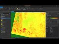 Change Detection in ArcGIS Pro
 Cloud Compare - Trace a polyline in a point cloud
 Aligning and Merging Meshes with Cloud Compare
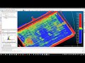 Surface deformation analysis using a point cloud
 Cloud Compare 6: Colouring LiDAR point clouds for Sketchfab with CC and LAStools
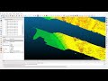 Cloud Compare 3: Creation of slices and sections
 How architects can survey and accurately draw a complicated building elevation by taking just one me
 Landsat Change Detection Using ArcGIS
 Cloud Compare 12: Saving workspace, Display options and Rendering views
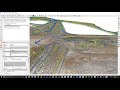 Automated Slope Breakline Classification with CloudCompare
 Open3D: A Modern Open-Source Library for 3D Data Processing
 Cloud Compare - Point List Picking tool
 Making a DEM from LiDAR point-cloud data in ArcMap
 How do align a point cloud with GCPs in CloudCompare?
 Cloud Compare 10: Solving issues when interpolating data from other entities
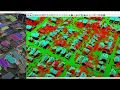 Quick Terrain Modeler Tutorial - Point Cloud Classification & Building Extraction