Cloud Compare: Colouring LiDAR point clouds for Sketchfab with CC and LAStools
In this video you will learn how to colour LiDAR point clouds using LASTools (in QGIS) and Cloud Compare. Initially, the LiDAR point cloud were coloured using LAScolor tool in QGIS (installation details provided) by extracting RGB values from a georeferenced very high resolution (VHR) aerial image from Nearmap. Then, point clouds were segmented and recoloured in Cloud Compare by mixing the Illuminance PCV values estimated by ShadViz (plugin) with the RGB colours assigned with LAScolor tool. Finally, I provide some tips to upload your model to Sketchfab and quick edit settings.
Dataset: ELVIS Geoscience Australia (https://elevation.fsdf.org.au/)
VHR aerial Image: https://www.nearmap.com/au/en
Cloud Compare: https://www.danielgm.net/cc/
LASTools: http://lastools.org/
Sketchfab model: https://skfb.ly/6Xquq
Видео Cloud Compare: Colouring LiDAR point clouds for Sketchfab with CC and LAStools канала Carlos Bartesaghi Koc, PhD
Показать
Комментарии отсутствуют
Информация о видео
10 декабря 2020 г. 5:58:12
00:38:28
Другие видео канала
 PIX4D - Cálculo Volumétrico y georreferenciación (GCP)
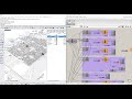 Grasshopper 11: Urban modelling from Open Street Map with Elk
 Cloud Compare - Point segmentation
 Grasshopper 5: Creating and remeshing terrains with Bison
 Getting Started with LIDAR
 Sketchfab - How to create a 3D model using the DEM-Net Elevation API tool
 Grasshopper 1: Creation of terrain from DTMs using Docofossor
 Cloud Compare: Assigning GeoTIFF (raster) values to LiDAR point clouds
 Tech Talk: Create 3D engineering-ready reality meshes using LiDAR and photos
 Grasshopper 12: Sunlight hours and radiation analysis with Ladybug
 Cloud Compare - Generate DEMs and Contours
 Grasshopper 9: Generative Plantings from LiDAR and using Image sampling
 Crear polígono de vuelo en Google earth para pix4d capture
 Lidar360 & Cloud Compare - Remove Noise
 3D point clouds from drone imagery -- WebODM, Meshlab, GRASS 7.4
 Mapping with Mavic 2 Pro/Zoom and SmartController
 Wix Dynamic Pages
 Grasshopper 3: Terrain modelling and grading using Docofossor
 Plas.io - A free online LiDAR data viewer/analyser
 Blender GIS