Route Planning with FAR (Fast, Attemptable Route) Planner. [Coming soon]
Video shows FAR (Fast, Attemptable Route) Planner in action in a simulated tunnel network environment. FAR planner is able to work in both known and unknown environments. In known environments, it plans paths based on the prior map. In unknown environments, it is attemptable to figure out a way to bring the vehicle to the goal by picking up the environment layout and building a global visibility graph along the way.
Here, the vehicle is commanded to go to two goal-points in an unknown environment. The white-colored overall map on the right side is unknown to the planner and the yellow-colored traversed areas are known. The blue-colored navigation path is searched on the cyan-colored visibility graph built in the traversed areas. In the end, the vehicle uses the visibility graph to navigate back home.
FAR planner runs in Autonomous Exploration Development Environment. Our targeted open-source release is in Oct 2021.
https://www.cmu-exploration.com
Видео Route Planning with FAR (Fast, Attemptable Route) Planner. [Coming soon] канала Fan Yang
Показать
Комментарии отсутствуют
Информация о видео
Другие видео канала
 iPlanner: Imperative Path Planning
![RRT-based Exploration Algorithm in Random Cave Environment [NUC Drone setup]](https://i.ytimg.com/vi/V1uxSvs6ZLE/default.jpg) RRT-based Exploration Algorithm in Random Cave Environment [NUC Drone setup]
RRT-based Exploration Algorithm in Random Cave Environment [NUC Drone setup] Real-Time Stair Detection Algorithm from LiDAR scans
 FAR Planner: Fast, Attemptable Route Planner using Dynamic Visibility Update
 Topological Exploration in DARPA SubT Virtual Cave Environment
![Route Planning with FAR(Fast, Attemptable Route) Planner. [Coming soon] (Photorealistic Environment)](https://i.ytimg.com/vi/dYqzB0hT66Q/default.jpg) Route Planning with FAR(Fast, Attemptable Route) Planner. [Coming soon] (Photorealistic Environment)
Route Planning with FAR(Fast, Attemptable Route) Planner. [Coming soon] (Photorealistic Environment)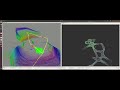 Topological Exploration with CMU-OSU SubT NUC Drone setup in Random Cave Environment
 Ground Refined LeGO LOAM
 Graph-Based Topological Exploration Planning in Large-Scale 3D Environments (ICRA 2021)
 Pittsburgh Fall 2020
 Distributed omnidirectional propulsion Aircraft
 Perception and Grasping after Motion for Static Objects
 Lucas–Kanade with PCA for adaptive human tracking on UAV