How to Download Aster Global DEM Version 3 from Earthdata: Newly Released
In this video, I have clearly shown the steps required to Download Aster GDEM V3 from Earthdata.
#sharingiscaring
#pleasesusbcribe
Видео How to Download Aster Global DEM Version 3 from Earthdata: Newly Released канала Tech-tutor with Fitsum
#sharingiscaring
#pleasesusbcribe
Видео How to Download Aster Global DEM Version 3 from Earthdata: Newly Released канала Tech-tutor with Fitsum
Показать
Комментарии отсутствуют
Информация о видео
12 августа 2019 г. 19:02:09
00:03:53
Другие видео канала
 Downloading a Digital Elevation Model (NASA) from NASA EarthData –Tutorial
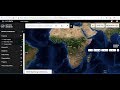 How to Download ASTER DEM 30m Data for FREE
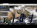 Getting Started with NASA Worldview
![How to download Aster DEM [New website-https://search.earthdata.nasa.gov/search] ?](https://i.ytimg.com/vi/QjSC6fl4o0k/default.jpg) How to download Aster DEM [New website-https://search.earthdata.nasa.gov/search] ?
How to download Aster DEM [New website-https://search.earthdata.nasa.gov/search] ? Grant Boxer - Geoscience applications of QGIS: a bold new world in mineral exploration
 How to look at and download streamflow data from the USGS NWIS website
 How to Download ASTER GDEM V3 | 30m Resolution | Free | Digital Elevation Models
 How to extract contour lines And DEM from Google Earth
 Download ASTER GLOBAL DEM Data from Earth Explorer
 Download Free 10m Satellite Image for Entire World | Sentinel Imagery
 QGIS Lessons-7 How to create False Color Composite (FCC) Or Band Composite using Landsat 8 Data
 Kaggle Earthquake Prediction Challenge
 Downloading Landsat 8 satellite image data to use in a GIS
 how to Download Sentinel 2 satellite images data
 Download High Resolution DEM 12.5 m | Télécharger MNT haute résolution
 Generation of DEM (Digital Elevation Model) using XYZ data in ArcMAP or ArcGIS
 How to Download Aster Global Water Bodies from Earthdata
 Extracting Elevation Data from Google Earth
 Download DEM Digital Elevation Model 10 meters by Global Mapper