How to 3D Carve a Topographic Map on an XCarve CNC Router: Mt. Katahdin
This video shows the process I use to create and 3d carve a topographic map of Mt. Katahdin on my XCarve. I use the STL file to carve a 10” x 7.75” model on my X-Carve CNC, using a 3” block of African mahogany.
The toolpaths are created in VCarvePro V10 using the Roughing Toolpath option and the Detail Toolpath option.
.25 Endmill for Roughing Pass
2mm Tapered Ballnose for Detail Pass
Topographic Map Website:
https://touchterrain.geol.iastate.edu/
—————————————
Amazon Affiliate Links:
Wyze Cameras:
https://amzn.to/2TNzVYH
Sanding Mop:
https://amzn.to/30IqzP7
Painter’s Standoffs:
https://amzn.to/2THZrhT
Whiteside .25” Downcut Endmill:
https://amzn.to/2THZmL7
Tapered Ballnose:
https://amzn.to/2TVQ4eL
Watco Black Walnut Danish Oil:
https://amzn.to/30HrK1n
Rubber Feet Bumpers:
https://amzn.to/30FgR07
Видео How to 3D Carve a Topographic Map on an XCarve CNC Router: Mt. Katahdin канала American South Designs
Показать
Комментарии отсутствуют
Информация о видео
Другие видео канала
 How To Create A 3D Topographical Map On A CNC
 Machining a Topographic Model in Carbide Create Pro
 Color Filled CNC Plaque on the Shapeoko
 10 Things I’ve learned making my first 10K with my Shapeoko // CNC
 Making a Topographic Carving with MeshCAM
 Carving Wyeast
 CNC Project: Machining a Citrus Canyon | ToolsToday
 X-Carve 3D Relief Carving
 Fusion 360 vs. Easel on the X-Carve - LMSAT
 Building a CNC Cart & Computer Cabinet for my X-CARVE PRO | Free Plans
![Carving a Topographic Map of Colorado from an STL - #131 [CNC]](https://i.ytimg.com/vi/-e8nKcaUh9U/default.jpg) Carving a Topographic Map of Colorado from an STL - #131 [CNC]
Carving a Topographic Map of Colorado from an STL - #131 [CNC] 5 CNC Projects You Can Make / Sell And The Bits Used
 3D Terrain Carving CNC Step-by-Step Guide
 How to do a Two-Stage Carve on an X-Carve CNC Router Using Easel
 Onefinity Woodworker vs X carve 1000mm // Best CNC machine to buy?
 Let’s Carve This Simple 3D Eagle on the CNC
 X-Carve Zero to Hero - My First Project
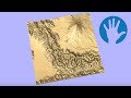 Tips & Tricks | Creating a 3D Terrain Map with Edward | Vectric
 X-Carve Upgrade: (DIY) Inventables X-Carve Upgrade//1800 mm XCarve (2019) Hack
 CNC Project: Cutting the State of California Topographical 3D Map | ToolsToday