3D Terrain Carving CNC Step-by-Step Guide
In this comprehensive tutorial we show you detailed steps involved in how to take topography data from any place on earth and recreate it on your CNC machine. In this guided walkthrough we cover using Blender and Fusion360. This could also be done in Vectric VCarve Pro. —If you have any questions please ask them in the comments. Hope you find the tutorial useful.
Please share, like and subscribe if you find it beneficial and want more guides like this! 😊
In this tutorial we carved the topographic map out of a piece of oak hardwood. The roughing operation was done with a 6mm single flute carbide endmill, and the 3D carving was done with a 1/16 Inch ballnose endmill. We used the superglue and painters tape method for hold down. The carving was finished by pouring in epoxy resin tinted blue to recreate the water / river.
Software Used:
Google Earth: https://earth.google.com/
Terrain Data: http://jthatch.com/Terrain2STL/
Blender3D: https://www.blender.org/
Autodesk Fusion 360: https://www.autodesk.com/products/fusion-360/overview
Видео 3D Terrain Carving CNC Step-by-Step Guide канала BG Precision
Показать
Комментарии отсутствуют
Информация о видео
Другие видео канала
 How to Create 3D Terrain with Google Maps and Blender!
 Making a custom lake depth chart from one piece of plywood
 Tips & Tricks | Creating a 3D Terrain Map with Edward | Vectric
 Machining a Topographic Model in Carbide Create Pro
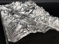 CNC fräsen milling Topographical 3D Map Topography Landscape topographische Karte
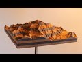 MPCNC 3D Mountain Carving - Denali
 Carving Wyeast
 HOW TO READ TOPOGRAPHIC MAPS // Basic Land Navigation Part 1
 Fusion 360 CNC 3D Carving for Beginners || HOW TO
 Making a Topographic Carving with MeshCAM
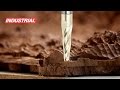 CNC Project: Cutting the State of California Topographical 3D Map | ToolsToday
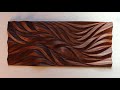 CNC Hardwood Wall Art with the MPCNC
 Google Maps to STL
 Simple Lampshade using Fusion 360 and a Laser Cutter
 How to design and make maps on your CNC router Carbide Create Turorial
 UCLA's Augmented Reality Sandbox
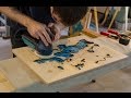 Failed Projects: Wooden Lake Maps
 How to 3D Carve a Topographic Map on an XCarve CNC Router: Mt. Katahdin
 Beginners guide to vbit carving - Fusion 360 - MPCNC
![Carving a Topographic Map of Colorado from an STL - #131 [CNC]](https://i.ytimg.com/vi/-e8nKcaUh9U/default.jpg) Carving a Topographic Map of Colorado from an STL - #131 [CNC]
Carving a Topographic Map of Colorado from an STL - #131 [CNC]