Space and time analysis in ArcGIS pro
Hello everyone, and welcome to my channel, Space Remote Sensing and GIS. Today, we're going to talk about how we can analyze data using both space and time in ArcGIS Pro.
When we talk about space and time analysis, we're looking at how things change in a certain area over a period of time. By studying these changes, we can find patterns or trends that help us understand how things might change in the future.
ArcGIS Pro is a software that helps us do this kind of analysis. It has tools that let us look at data in different places and times, so we can see how things have changed and predict how they might change in the future. Understanding these changes can help us plan better for the future.
Видео Space and time analysis in ArcGIS pro канала Space, Remote sensing and GIS
Показать
Комментарии отсутствуют
Информация о видео
10 марта 2024 г. 8:35:24
00:18:52
Другие видео канала
 Forest fire assessment using indices and change detection tool in ArcGIS Pro
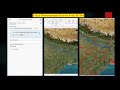 How to trace downstream in ArcGIS Pro
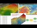 UTM excel DGPS data conversion for mining
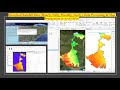 Download Rainfall Data Hourly, Daily, Monthly, Yearly, Data Processing & Map Preparation in ArcGISPr
 Exploring Historical High-Resolution Images with ArcGIS Pro: Identifying Changes in Varanasi City
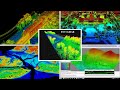 ENVI LIDAR
 River Stream Order Map in ArcGIS Pro
 Use Neighborhood Explorer tool in ArcGIS Pro
 Download Water body data (Shapefile) Lakes, River, Wetland of any Location and open it in ArcGIS Pro
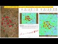 Extract multi value points and Co Relationship estimation, chart preparation
 Watershed/ catchment extraction in ArcGIS Pro
 ACE Target Detection over Hyperspectral Data
 ENVI Crop science tool for precision agriculture
 NDVI with ArcPy for Python Developers using ArcGIS Pro
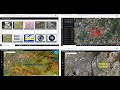 ESRI imagery web-apps and use Sentinel-2 and Landsat Imagery with ArcGIS Pro
 Captivating Image of Cyclone Biparjoy Reveals Unprecedented Details: Download and Analyze
 Roop kund Trek base point video created using ArcGIS Pro Animation tool
 Extract Elevation Values from DEM
 Direction and Distance for urban expansion in ArcGIS Pro
 Cloud removal in satellite image
 Creating 3D Sea Level Rise Maps with ArcGIS Pro: A Visual Exploration part 1