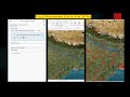
Roop kund Trek base point video created using ArcGIS Pro Animation tool
This video is created in ArcGIS pro animation tool using esri base map high resolution satellite image. This video will show you full path of our route during roopkund trek. Which is started from wan village then Chatrolig Patal then via Bedini Bugyal then pathar nachuni then Bhagwa basa and finally Roop kund which is almost 5500 mt height. Feeling great that ArcGIS Pro software have this capabilities to make my trek as a wonderful memories. In coming tutorial will show you how I created this video please subscribe my channel.
Full practical demo link
https://www.youtube.com/watch?v=jcNoVZl0eq0
Видео Roop kund Trek base point video created using ArcGIS Pro Animation tool канала Space, Remote sensing and GIS
ESRI, ArcGIS Pro animation Tool, Animation in ArcGIS Pro, arcgis pro animation, arcgis online, Trek video animation, Roop kund trek
Показать
Комментарии отсутствуют
Информация о видео
1 сентября 2022 г. 21:12:36
00:01:01
Другие видео канала
 How to trace downstream in ArcGIS Pro
 UTM excel DGPS data conversion for mining
 Download Rainfall Data Hourly, Daily, Monthly, Yearly, Data Processing & Map Preparation in ArcGISPr
 Exploring Historical High-Resolution Images with ArcGIS Pro: Identifying Changes in Varanasi City
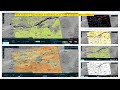 Exploring Sentinel-1 SAR Data with ESRI's New Sentinel-1 Explorer Tool
 Updating ArcGIS hub and dashboard from ArcGIS and ArcGIS Pro
 Mapping Deforestation Patterns in Brazil and India with ArcGIS Pro's Living Atlas
 ENVI LIDAR
 Impact Observatory’s LULC Data: A Step-by-Step Guide for ArcGIS Pro Users
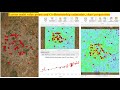 Extract multi value points and Co Relationship estimation, chart preparation
 ACE Target Detection over Hyperspectral Data
 Transforming Geospatial Data: The Latest Industry Advancements
 ENVI Crop science tool for precision agriculture
 How to Generate Precise DEMs from SAR Data with InSAR in ENVI SARscape
 NDVI with ArcPy for Python Developers using ArcGIS Pro
 ESRI imagery web-apps and use Sentinel-2 and Landsat Imagery with ArcGIS Pro
 Captivating Image of Cyclone Biparjoy Reveals Unprecedented Details: Download and Analyze
 Extract Elevation Values from DEM
 Direction and Distance for urban expansion in ArcGIS Pro
 Enhancing SAR Image Quality: Multilooking Data Processing in ENVI Sarscape and ArcGIS Pro
 Cloud removal in satellite image