Increase Agricultural Efficiencies Using Satellite Imagery | Webinar
As anyone living in a major drought region will tell you, water has become the new gold. Properly conserving and managing our most valuable natural resource is becoming more and more important as the world’s climate changes. Everyone from local farmers to national government agencies are using innovative techniques, including geospatial technologies to improve water conservation and increase agricultural efficiencies overall.
In this webinar, see how the combination of imagery from Airbus Defense and Space and the advanced ENVI image analysis software from Exelis can be used to increase agricultural efficiencies, including estimating crop yields and water content, identifying stressed plants, combating disease and pests, and more.
Видео Increase Agricultural Efficiencies Using Satellite Imagery | Webinar канала L3Harris Geospatial Solutions
Показать
Комментарии отсутствуют
Информация о видео
3 ноября 2015 г. 21:39:26
00:56:58
Другие видео канала
 RUS Webinar: Rice detection with Sentinel-1 using SNAP GPT - LAND10
 Geospatial Intelligence: What is it and where are the jobs?
 A Hitchhiker’s Guide to Hyperspectral Data | Spectral Sessions
 Forecasting Crop Productivity with High-Resolution Satellite Data: Scaling Up to the Whole...
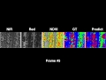 weedNet: Dense Semantic Weed Classification Using Multispectral Images and MAV for Smart Farming
 Land Monitoring Service - Submodule H: Agriculture – global component
 DSLRPros Sentera NDVI Webinar Recap
 Satellite Earth Observation for Agricultural Monitoring
 15 Modern Farming Technologies that are NEXT LEVEL
![[QGIS APPLICATION] Multiple Criteria Decision Making For Selection of Suitable Agricultural Land](https://i.ytimg.com/vi/TDwg8Wi5rYs/default.jpg) [QGIS APPLICATION] Multiple Criteria Decision Making For Selection of Suitable Agricultural Land
[QGIS APPLICATION] Multiple Criteria Decision Making For Selection of Suitable Agricultural Land NDMI | How to Calculate Normalized Difference Moisture Index in ArcGIS
 Remote Sensing for National Security Using Hyperspectral Imagery and SAR
 Data Management for GIS Projects
 RUS webinar: Freshwater Quality Monitoring with Sentinel-2 - HYDR02
 NASA ARSET: Satellite Data for Monitoring Urban Flooding, Part 2/2
 Showing Your Hyperspectral Data Who’s the Boss | Breakout Spectral Session
 Lecture 41: NDVI and other indices
 Getting Started with MODIS Version 6- Vegetation Indices Data (Part1)
 Remote Sensing Basis of Crop Monitoring by Dr. K R Manjunath, ISRO
 Sen2Agri installation and configuration