Forecasting Crop Productivity with High-Resolution Satellite Data: Scaling Up to the Whole...
"Forecasting Crop Productivity with High-Resolution Satellite Data: Scaling Up to the Whole US Corn Belt" -- Sibo Wang, University of Illinois at Urbana-Champaign
High-performance computing, along with satellite datasets that provide a wide spatiotemporal coverage of agricultural lands, enables a novel and data-oriented approach to understand crop growth. Using Blue Waters, we developed a hybrid crop model (CLM-APSIM) that produces reliable long-term yield predictions in the US Corn Belt. We also developed a generic multi-sensor fusion algorithm, STAIR, that integrates satellite images at a variety of spatial and temporal resolutions. Finally, a pixel-level crop yield model, ASPIRE, uses remotely sensed images, soil condition, and climate data to predict crop yield at field level. The ultimate goal of our project is to improve our predictability skill for global crop yield modeling by integrating site measurements, satellite observations, and process-based modeling.
Видео Forecasting Crop Productivity with High-Resolution Satellite Data: Scaling Up to the Whole... канала NCSAatIllinois
Показать
Комментарии отсутствуют
Информация о видео
Другие видео канала
 The Rare-Earth Elements That Will Change Our Future | Treasure Hunters | Spark
 RUS webinar: Vegetation monitoring for Agriculture with Sentinel-2 - LAND11
 Meha Jain - A Scalable Satellite-based Crop Yield Mapper
 Crop Yield Estimation from Satellite for Tropical Agriculture
 How are drones helping farmers keep an eye on crops? | SciTech Now
 Machine Learning and Agriculture: Precision Ag, Remote Sensing, and the Soil Microbiome
 AGRO-CLIMATIC CROP SUITABILITY ANALYSIS USING DIVA GIS
 Introduction to Hyperspectral Remote Sensing: A Presentation
 Modeling crop yields with tidy data principles
 Hyperspectral Imaging in Precision Ag
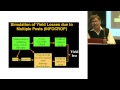 ILSI India: Simulating Agricultural Processes With Crop Models (Dr. Naveen)
 Data Assimilation lecture 1
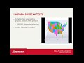 Time-series weather based yield prediction
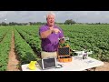 Drone and Technology for Precision Agriculture
 Webinar - Monitoring croplands using remote sensing, ground data & machine learning algorithms
 Fixing On The Ford
 The Future of Farming: With Satellite Imagery, Weather Data, & Deep Learning | UP42 Webinar
 Increase Agricultural Efficiencies Using Satellite Imagery | Webinar
 Class 1: Introduction to Training on Computable General Equilibrium Modelling
 Land Cover Classification using the Semi-Automatic Classification Plugin version 7