How to Calculate area of Raster image (DEM) in ArcGis
It is a step wise tutorial of how to find area of any DEM in arcgis.
Видео How to Calculate area of Raster image (DEM) in ArcGis канала Engineering Times
Видео How to Calculate area of Raster image (DEM) in ArcGis канала Engineering Times
Показать
Комментарии отсутствуют
Информация о видео
Другие видео канала
 Estimating Lake Area Expansion Using NDWI for understanding changes and effects.
 How to Calculate area of different classes using ArcMap ( watch till end)
 Georeferencing Images in ArcGIS Pro
 0105 Calculate area of raster zones
 Area calculation of a classified (raster) image in ArcGIS 10
 Reclassify & Convert Raster to Shapefile ( Polygon) & Calculate Area Using ArcGIS
 Calculating the Area of the Raster data in ArcGIS
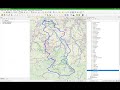 Stream and Catchment Delineation in QGIS 3 using GRASS tools
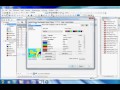 Week06 s02 Area calculation in Raster
 Create TIN, DEM and Slope from Contour Line by ArcGIS
 Watershed Delineation using Arc Hydro Tool in ArcGIS
 ArcGIS and Hec-Georas: River Cross Sections | HEC-RAS | Part 2 of 5
 How to Make a Map using QGIS3
 Watershed Delineation and Watershed Characteristics in ArcGIS Pro
 Calculo de volumen, altura, cota, área espejo de agua Embalses en ArcGIS
 Create hypsometric curve from DEM
 Slope Analysis from DEM in ArcGIS || Slope-Wise Area Calculation || @GeoTech Studio
 Groundwater Potential zone Mapping in Arc GIS using Analytic Hierarchy Process (AHP) - Part 1
 Map Document Properties Store Relative Pathnames to data sources | a GIS Video by Gregory Lund
 NDVI area calculation | Calculate area from pixel | NDVI values range