Exploring Dams and Canyon along the South Fork of the Boise River
This area is north of Boise. The flight takes off from Nampa (KMAN) heading east. Video begins with the southern part of Anderson Ranch Reservoir to the left of the airplane. It flies north to the northern end of the reservoir and circles a dirt landing strip, Pine. Then it heads back south to the area of the dam which is one of several dams along the south fork of the Bose River. You can see how the river has carved out a small canyon on either side. The flight follows that for a little while, then diverts north about 20 miles to Smith Prairie airport-another back country dirt strip-circles that airstrip and then heads back to the Boise River until it ends at Lucky Peak Dam. Total flying time about 2 hours. Total video time less than 7 minutes.
Видео Exploring Dams and Canyon along the South Fork of the Boise River канала MASMECO
Видео Exploring Dams and Canyon along the South Fork of the Boise River канала MASMECO
Показать
Комментарии отсутствуют
Информация о видео
Другие видео канала
 Landing Pattern work in Waiex by Sonex-Nampa-Caldwell
 MECO Agility--ASCAOpen11-09
 MECO Agility-DelValle-StandardExcellentB-10-17-09
 WASP 80th Anniversary Part 1- from Nampa Idaho to Santa Fe, New Mexico
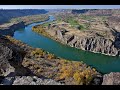 Snake River Between Marsing and Homedale
 MOCI and the Quest for the ASCA 2019 Novice Silver Buckle Award
 MECO Agility-Std-6-13-2010.wmv
 Maverick: Master of the Yuppy Puppy Dog Treat Machine
 CBH Development in Caldwell
 MECO Agility-JWW-DoubleQ
 Garden Valley (Idaho) Fathers Day Fly In 6 20 21
 Landing Pattern work in Waiex by Sonex-Caldwell-Nampa
 South Fork Boise River Valley and Dams 5-15-22
 Waiex 1299P-Testing Mixture Settings
 Waiex Landings--View from the Left Seat
 Waiex- Understanding Stalls and Slips
 One Mind Dog-Lateral Push
 WASP 80th Anniversary Part 3 Sweetwater, TX Green River, NM
 Canyon County Elementary School--Development at Homedale-S Florida Ave in Caldwell, ID
 MECO Agility-DoubleQ-JWW-05-16-2010