2011 Joplin EF5 Tornado Path and Destruction on Google Earth
This video gives an overview of the path and destruction caused by the 2011 Joplin Missouri EF5 Tornado. Most of the video uses Google Earth and Google Maps.
Additional footage:
Army Corp of Engineers Path and Destruction:
https://www.flickr.com/photos/usace-kcd/5918338145/
Safe Deposit Box:
Andy Ringsmuth
St. Johns Regional Medical Center:
Intelati
Rangeline Road Before:
RODALCO2007 - https://youtu.be/CburjPYmSdo
Rangeline Road After:
State of Missouri - https://youtu.be/8hH2zY1ktAA
Thanks for Watching!
Видео 2011 Joplin EF5 Tornado Path and Destruction on Google Earth канала Swegle Studios
Показать
Комментарии отсутствуют
Информация о видео
Другие видео канала
 (1 of 5) The Joplin Tornado: EP 1 - Arrival
 Devastating Joplin, Missouri EF-5 Tornado - May 22, 2011
 2011 Tuscaloosa and Birmingham EF4 Tornado - Path and Destruction from Google Earth
 2011 Alabama Super Outbreak Tornado Paths Scars and Damage Overview From Google Earth
 2013 Moore EF5 Tornado Synced
 28 STRANGE Sights on Google Earth
 Joplin Storm Passes Pierce City, Missouri, May 22, 2011
 Washington, Illinois Tornado Path and Destruction as seen on Google Earth.
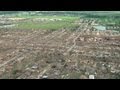 Aerial View Of EF5 Tornado's Path - Moore, OK 2013
 FASTEST MOVING TORNADO - New World Record
 El Reno: Lessons From the Most Dangerous Tornado in Storm Observing History
 James Spann's live coverage of April 27, 2011 tornado outbreak on ABC 33/40
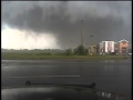 NPD Dashcam Tornado Video
 2013 Moore Oklahoma EF5 Tornado Path and Destruction on Google Earth
 EF4 Tornado Newnan GA 03-26-21 Actual Footage
 Tornado Footage from Front Door 7/23/2019
 Escaping the largest EF5 tornado in history - El Reno, OK - full dashcam sequence
 3-2-2020 WTVF Nashville Tornado Coverage
 Main Street before and after the May 22nd tornado in Joplin
 Storm Chasing Physician First Hand Response to Joplin Tornado