Tracking Deluge and Drought through Soil Moisture: Part 1
From soaked to dry, the variable state of U.S. soils has implications for farmers and crop production. The opposing extremes are detected by NASA satellites. A novel tool—the Soil Moisture Analytics (Crop-CASMA) product—integrates this satellite data into a format that is particularly useful to people.
Part 1 shows Crop-CASMA data during a period of abundant moisture (March through July 2019): https://youtu.be/niYadxR32Nc
Part 2 shows Crop-CASMA data as drought returned and parched much of the United States (March 2021 through June 2022): https://youtu.be/5UzwHTb9mnE
Read the full story here: https://go.nasa.gov/3bhHSjU
NASA Earth Observatory animations by Joshua Stevens, using soil moisture data from Crop Condition and Soil Moisture Analytics (Crop-CASMA). The Crop-CASMA product was developed by scientists at the U.S. Department of Agriculture (USDA), George Mason University, and NASA's Goddard Space Flight Center and Jet Propulsion Laboratory. Crop-CASMA integrates measurements from NASA's Soil Moisture Active Passive (SMAP) satellite and vegetation indices from the Moderate Resolution Imaging Spectroradiometer (MODIS) instruments on NASA's Terra and Aqua satellites. Story and videos by Kathryn Hansen with information from Rajat Bindlish/NASA GSFC. Music: "Summer" by Benjamin Tisson via Bensound.
Видео Tracking Deluge and Drought through Soil Moisture: Part 1 канала NASAEarthObservatory
Показать
Комментарии отсутствуют
Информация о видео
Другие видео канала
 Earth Science Week 2011: Web resources overview
 Water vapor over Africa and the Atlantic Ocean
 Shuttle Discovery and ISS go from night to day, with aurora
 Global Temperatures 1880-2011
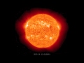 Side View of M8.7 Solar Flare from STEREO-A
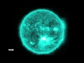 X1.4 Solar Flare at 131 Angstroms
 Migration Mystery: Robin Song
 X1.4 Solar Flare at 171 Angstroms
 Majestic Planet
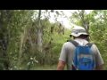 Tour Guide Andres Vergara at the Galapagos Islands
 Oceans Melting Greenland (OMG) Field Campaign: Vlog #3
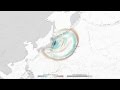 2011 Japan Tsunami Wave Height, the First 2.4 Hours
 Tournament Earth 2021: Astronaut Photography
 Galapagos Tour Fly-by
 Pelicans at the Market
 Landsat Goes Over The Top: A Long View of the Arctic
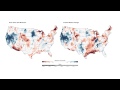 Water Storage Maps Show Improvement
 Wild Weather off Alaska
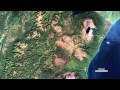 Kamchatka: The Erupting Peninsula
 Cyclone Causes Soggy Weather East of the Mississippi