Leica DISTO™ S910 – 3D measuring revolution
Find out more about the revolutionary Leica DISTO™ S910 laser distance meter: http://leica-geosystems.com/disto_s910
Measure anything from anywhere.
Measure fast and precisely distances between any two points from one location with the laser distance meter Leica DISTO™ S910. Create easily as-built documentation, calculate roof dimensions and integrate data into BIM or CAD software for 3D visualizations. These improved workflows save valuable time and money – all this at ranges of up to 300 m.
Measure from point to point with P2P Technology
The integrated Smart Base enables to measure distances (e.g. widths and tie distances) between any two points, angles and inclinations at the same time from one location. Thus, you’ll never have to reach for inaccessible areas again, enabling even the most complex measurement task to be carried out quickly, accurately and safely.
Capture measurement data in CAD format
The Leica DISTO™ S910 laser range finder can save all the measured points into a DXF file as a floor plan, wall layout or 3D point coordinates that can be downloaded to a PC via the USB interface. Shorten the workflow, save money and avoid mistakes: because it’s completely digitalised. Writing errors are a thing of the past.
Real-time transfer of point data
Transfer measurement data directly on site over the WLAN interface to a portable computer for further processing in your preferred software. Create documentation or check a lay-out in real-time and transmit as many measurement points as you like – with or without pictures.
300 m range with X-Range Power Technology
With the innovative X-Range Power Technology on board the Leica DISTO™ S910 laser measure represents the measuring technology of the future. It achieves ranges of up to 300 m and guarantees the best measuring performance even to poorly reflecting objects.
Видео Leica DISTO™ S910 – 3D measuring revolution канала Leica Geosystems AG
Показать
Комментарии отсутствуют
Информация о видео
Другие видео канала
 HxGN LIVE 2014 Geosystems Keynote "Dirt, Diamonds and Data"
 Leica Rugby 800-series construction lasers
 HxGN SmartNet – Comment ça marche
 Teodoliten are working more efficiently with the Leica Geosystems automated monitoring solutions
 HxGN LIVE Conference Wrap up
 How to setup and demonstrate the PA 80 solution
 Introduction to Public Safety, Security and Forensics solutions at Leica Geosystems, part of Hexagon
 HxGN SmartNet Global
 How does machine control work
 How to save 5 minutes per pile with an integrated piling solution?
 75mm Studio uses 3D Laser Scanning to create stunning film and gaming visuals
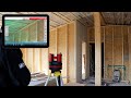 Leica 3D Disto: Wie misst man manuell?
 Leica Nova Launch #HxGNLIVE
 Real-Time Surface Logging: Unleashing Cutting-Edge Technology
 Using dual TPS
 Monitoring for construction sites – Leica Geosystems Monitoring Solutions
 Criminal Investigation solutions at Leica Geosystems (part of Hexagon)
 Using the command center
 What are height and side offsets in machine control?
 Accesorios Leica Originales - CPEC Leica Geosystems
 Leica iCON field v7.5: What`s new in the software release for heavy construction