- Популярные видео
- Авто
- Видео-блоги
- ДТП, аварии
- Для маленьких
- Еда, напитки
- Животные
- Закон и право
- Знаменитости
- Игры
- Искусство
- Комедии
- Красота, мода
- Кулинария, рецепты
- Люди
- Мото
- Музыка
- Мультфильмы
- Наука, технологии
- Новости
- Образование
- Политика
- Праздники
- Приколы
- Природа
- Происшествия
- Путешествия
- Развлечения
- Ржач
- Семья
- Сериалы
- Спорт
- Стиль жизни
- ТВ передачи
- Танцы
- Технологии
- Товары
- Ужасы
- Фильмы
- Шоу-бизнес
- Юмор
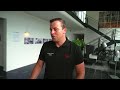
Introduction to Public Safety, Security and Forensics solutions at Leica Geosystems, part of Hexagon
Leica Geosystem’s geospatial technology, serves Public Safety, Security and Forensic professionals around the world, transforming the way crime scene investigators and police officers, crash investigators, fire investigators, and security professionals manage pre-planning, forensic mapping, evidence gathering, incident and scene investigation to create a Forensic Digital Twin.
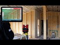
Our measurement and positioning technology (3D laser scanners, imaging laser scanners, total stations, mobile mapping) accurately collects all the evidence in a variety of formats, from point data and photogrammetric imagery to 3D point cloud data.
It enables professionals to fully capture the reality creating a Forensic Digital Twin and clear scenes quickly, reducing disruption, making digital documentation and mapping safer, minimising risks, and protecting response teams and the public.
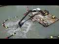
Back in the office, a wide array of deliverables can be created from the digital datasets with specialised forensic mapping software allowing investigators to re-visit the Forensic Digital Twin of the scene from multiple angles and reconstruct the incident exactly as it was.
Contact us to learn more:
https://leica-geosystems.com/industries/public-safety-security-and-forensics/contact-our-public-safety-experts
Видео Introduction to Public Safety, Security and Forensics solutions at Leica Geosystems, part of Hexagon канала Leica Geosystems AG
Our measurement and positioning technology (3D laser scanners, imaging laser scanners, total stations, mobile mapping) accurately collects all the evidence in a variety of formats, from point data and photogrammetric imagery to 3D point cloud data.
It enables professionals to fully capture the reality creating a Forensic Digital Twin and clear scenes quickly, reducing disruption, making digital documentation and mapping safer, minimising risks, and protecting response teams and the public.
Back in the office, a wide array of deliverables can be created from the digital datasets with specialised forensic mapping software allowing investigators to re-visit the Forensic Digital Twin of the scene from multiple angles and reconstruct the incident exactly as it was.
Contact us to learn more:
https://leica-geosystems.com/industries/public-safety-security-and-forensics/contact-our-public-safety-experts
Видео Introduction to Public Safety, Security and Forensics solutions at Leica Geosystems, part of Hexagon канала Leica Geosystems AG
• Forensic Digital Twin security forensics crash crime fire arson explosion investigation emergency response disaster management DRM forensic mapping reconstruction 3D visualisation • Public Safety Leica Public Safety Hexagon Public Safety Leica Forensics • laser scanner laser scanning 3D technology 3D laser scanner total station BLK360 Pegasus:Backpack BLK3D mobile mapping
Комментарии отсутствуют
Информация о видео
4 июля 2022 г. 19:20:00
00:02:41
Другие видео канала