levantamiento topografico con google earth
Muchas gracias por haber visto mi vídeo, recuerda que tus likes son el motor principal para continuar subir mas vídeos.
Con este vídeo tutorial, podrás saber, como hacer levantamiento topográfico con google earth o exportar superficie y curvas de nivel de google earth a civil 3d utilizando programa Global Mapper
link de descarga del programa GLOBAL MAPPER:
https://drive.google.com/file/d/1pIQO54Y8cEe8ghcOdcx3yxi9ZIoA-dI_/view?usp=sharing
Suscribete a mi canal y activa la camanita para que así cada vez que suba un vídeo te llegue a tu feed de youtube y a tu email.
restaurar autocad o civil 3d 2012 - 2018: https://www.youtube.com/watch?v=JGsIjCXt9t8&t=89s
canal:https://www.youtube.com/channel/UCfz_...
facebook:https://web.facebook.com/alex.Cayllah...
Видео levantamiento topografico con google earth канала Alfredo Cayllahua Taipe
Показать
Комментарии отсутствуют
Информация о видео
Другие видео канала
 Google Earth 2016 - Obtener puntos con sus coordenadas UTM y elevación.
 Tabla de Rumbos, Distancias y Coordendas Automatizadas en Autocad Civil 3D 12-19
 🌎 Como hacer TOPOGRAFIA 3D terreno y CURVAS de NIVEL | Sketchup Revit Google Earth Cad Global Mapper
 Como transformar un mapa de Google a un croquis de Autocad o illustrator
 Como Georreferenciar planos topográficos con goolge earth
 COMO PASAR COORDENADAS DE GOOGLE EARTH A EXEL PASO A PASO
 Levantamiento Topografico con Google Earth-Civil 3D🔥(TUTORIALCOMPLETO)
 Musica para estudiar y concentrarse y memorizar, Trabajar, Relajarse, Leer, Trabajar, Relajarse,Leer
 LEVANTAMIENTO TOPOGRÁFICO CON GOOGLE EARTH DEL RIO ICA
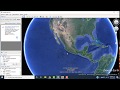 Como convertir de Google Earth a AutoCAD - convertir de KMZ a DXF
 MAQUILLAJE PARA PRINCIPIANTES PASO A PASO | Mariana Zambrano
 Como sacar curvas de nivel de Google earth para Autocad
 ⌚⏰⏲️ PLANTILLA (Template) AutoCad (como crear hacer guardar insertar configurar cargar) ARQUITECTURA
 AFICHE ARTÍSTICO PHOTOSHOP ARQUITECTÓNICO / POST PRODUCCIÓN
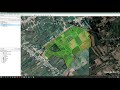 Levantamiento de predios agrícolas usando, Google Earth, Global Mapper y AutoCAD
 EXPORTAR PUNTOS Y CURVAS DE NIVEL DE GOOGLE EARTH - CIVIL 3D 2020.
 COMO TRAER O IMPORTAR UNA TOPOGRAFÍA DESDE GOOGLE EARTH A REVIT
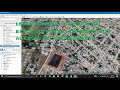 COMO EXPORTAR PUNTOS TOPOGRÁFICOS (UTM) DE GOOGLE EARTH A EXCEL, CIVIL 3D
 Como HACER un PERFIL TOPOGRAFICO con GOOGLE EARTH 🌍
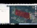 Cómo crear un POLÍGONO en Google Earth con coordenadas UTM de parcela ( pasó a paso)