Autonomous Exploration Path Planning in High-risk Environments using Aerial Robots
The PX4 Developer Summit is the annual flagship conference hosted by Dronecode for the drone development community. https://bit.ly/2YXe4Rd
Title: Autonomous Exploration Path Planning in High-risk Environments using Aerial Robots
Summary: In this talk we present a library of exploration path planning algorithms for aerial robots operating in high-risk settings such as underground environments. Given a previously unknown space, the exploration planners provide collision-free trajectories to navigate the space and build a complete map of the environment autonomously. The set of presented planners emphasize different aspects, such as on large-scale narrow-width subterranean environments, saliency-aware exploration, uncertainty-aware navigation and more. Among the multiple planners in the presented set, we will particularly emphasize on a novel graph-based planning framework purposefully built for aerial robots in subterranean environments such as underground mines, metropolitan infrastructure, and caverns. Given their often large-scale topology and complex network of branches, a bifurcated approach consisting of local and global planning layers is designed. The local planner employs a rapidly-exploring random graph to efficiently identify exploration paths within a local subspace. The global planner is developed as another layer to reposition the robot towards other unexplored areas over the global map when the robot reaches a dead-end situation. This planning algorithm is evaluated extensively in a variety of underground mines and bunkers in the U.S. and in Switzerland. The framework is also being used by the CERBERUS team in DARPA Subterranean Challenge which focuses on innovative robotics solutions for exploration and search missions in underground environments (https://www.subtchallenge.com/). Secondly, we will also focus on two multi-objective planners that co-optimize for exploration (extrinsic goal) and the intrinsic goals of localization uncertainty minimization and salient region re-observation. All the planners are interfaced via the Robot Operating System, a subset is open-sourced already, and to a great extent have been tested with PX4-enabled platforms.
A list of demonstration videos from our experiments and field deployments could be found at https://www.youtube.com/playlist?list=PL3qlfAXmuOFIr-m8ScWJXdDO88_feibTq
Software related to the proposed planners that are already open-sourced is available at
- Graph-based Exploration Planner for Subterranean Environments: https://github.com/unr-arl/gbplanner_ros (in progress)
- Motion-primitives Based Planner for Fast & Agile Exploration: https://github.com/unr-arl/mbplanner_ros (in progress)
- Visual Saliency-aware Exploration Planner: https://github.com/unr-arl/rhem_planner
- Uncertainty-aware Receding Horizon Exploration and Mapping: https://github.com/unr-arl/vseplanner
- Tutorial: https://www.autonomousrobotslab.com/subtplanning.html
https://sched.co/cjPA
Видео Autonomous Exploration Path Planning in High-risk Environments using Aerial Robots канала PX4 Autopilot - Open Source Flight Control.
Показать
Комментарии отсутствуют
Информация о видео
7 июля 2020 г. 23:30:29
00:16:18
Другие видео канала
 GPS-Denied Motion Planning on a DIY Drone with Computer Vision
 Perception-aware Path Planning
 Autonomously Exploring and Mapping a Large Indoor Environment with a Ground Vehicle
 Most amazing underwater robots
 How to plan 2D/3D survey missions on Wispr Drones using QGroundControl
 PAMPC: Perception-Aware Model Predictive Control for Quadrotors
 ROS2 Powered PX4 - PX4 Developer Summit 2019
 Swarms of Aerial Robots - AMNH SciCafe
 Taking Science to New Depths: Underwater Robots Designed - SOLIDWORKS
 Autonomous Fire Finding Using Aerial Robots
 ICRA 2022 Talk: Autonomous Exploration Development Environment and the Planning Algorithms
 Fisher Information Field: an Efficient and Differentiable Map for Perception-aware Planning
 Autonomous Drifting using Machine Learning
 ANYmal C Legged Robot Showcase
 RRT, RRT* & Random Trees
 PX4 / ROS2 integration and SITL improvements - Tully Foote - PX4 Developer Summit 2019
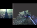 Outdoor stereo SLAM with RTAB-Map
 ECE425 Lecture6-1b: Topological Path Planning
 The future of Aerial Robotics: panel at the pop-up House of Switzerland
 Raspberry Pi Robotics #1: GPIO Control