ESA Echoes in Space - Land: Crop type mapping with Sentinel-1
Dr. Chris Stewart explains how to derive crop types from aSentinel-1 time series, using SNAP.
SNAP: http://step.esa.int/main/download/
Download Sentinel images: https://scihub.copernicus.eu/dhus/
Echoes in Space is the first Massive Open Online Course on Radar Remote Sensing, funded by the European Space Agency (ESA).
Register now: https://eo-college.org
Echoes from space will take you on a journey through the exciting world of Radar Remote Sensing. Learn the basics that will help you to understand where this technology is coming from, how the images are acquired and which manifold applications already use Radar Remote Sensing to help protect our planet.
Видео ESA Echoes in Space - Land: Crop type mapping with Sentinel-1 канала EO College
Показать
Комментарии отсутствуют
Информация о видео
Другие видео канала
 RUS Webinar: Crop mapping with Sentinel-2 - LAND01
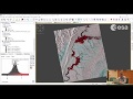 ESA Echoes in Space - Hazard: Flood mapping with Sentinel-1
 Methods for cropland/crop type mapping from S2 and/or S1 time series - Day 2.2
 ESA Echoes in Space - Geometry: Introduction to SNAP
 SNAP - Calculate Normalized Difference Vegetation Index (NDVI)
 Sentinel -1 (SAR) Radar data - Access and Processing with SNAP toolbox
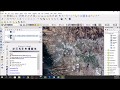 Downloading and preprocessing Sentinel 2 images using the Semi-Classification Plugin in QGIS 3.0
 ESA Echoes in Space - Land: Forest mapping with ALOS PalSAR
 Sen2Agri installation and configuration
 SNAP Tutorial (KUNO) Pre processing Sentinel 1A SLC SAR Images
 RUS webinar: Vegetation monitoring for Agriculture with Sentinel-2 - LAND11
 Prosesing Sentinel 1 - Dinsar - Insar
 ESA Echoes in Space - Land: Introduction to Forest Monitoring
 Download and Extract Soil Moisture Data from Sentinel 1 and SMAP using ArcGIS Desktop
 mosaicing, subsetting and masking raster datasets in SNAP
 ESA Echoes in Space - Land: Urban Footprint mapping with Sentinel-1
 Fusion of SAR and Landsat
 RUS Webinar: Rice detection with Sentinel-1 using SNAP GPT - LAND10
 Random Forest Classification with SNAP: Monitoring Clear Cut using multitemporal Sentinel-1
 Pre processing of sentinel 1 SAR data (Batch processing using Graph builder))