High Speed Tour around Wakefield, 1973/4 - SLOWED DOWN
High speed tour of Wakefield in early 1970s. Shot on Super 8, manually shooting one frame per second by cable release. Camera mounted in passenger window of car. Slowed down 3 times.
Date is estimated at 1973 or 1974, because we drive along Kirkgate which was pedestrianised shortly afterwards.
Route is from Sandal to Wakefield city centre along Barnsley Road, along Kirkgate, then along Westgate, Balne Lane, Batley Road, past Silcoates School, Wrenthorpe Lane, Northgate, Barnsley Road back to Sandal, then out towards Kettlethorpe and to J39 of M1.
Here's the route on a map http://www.gmap-pedometer.com/?r=6933200. Note that after crossing the Calder, we turned right from Ings Road into Grove Street after going under the railway bridge near Kirkgate station, which is not permitted nowadays. Also note the straight line sections across the middle of modern buildings just after turning right off Westgate into Drury Lane, and between the southern end of Northgate (near QEGS) and the roundabout with Kirkgate - roads have been re-aligned in those two places.
The trip at the end from our house to Kettlethorpe was to take the piano teacher home, and the final second is going under the M1 at J39 and turning north onto the M1 to go to my grandparents in Ossett - at which point we ran out of film :-(
Видео High Speed Tour around Wakefield, 1973/4 - SLOWED DOWN канала Mortimer50145
Показать
Комментарии отсутствуют
Информация о видео
Другие видео канала
 WAKEFIELD LET US NEVER FORGET
 No 26. Dashcam 1987 Style The Bullring To Heath Common Wakefield 5.5.87
 The EASIEST way to catch pike on lures!! UK Lure fishing How To
 WAKEFIELD - Past & Present (West Yorkshire)
 No.16 Dashcam 1990 Style.....A Drive Around Wakefield City Centre 8.4.90
 4K Scenic Drive - 4 HRS Relaxation Video with Music - King Ridge Road, California
 wakefield 1973.
 No 14. Dashcam 1984 Style.....A Christmas Drive 21.12.84. A Drive Around Castleford.
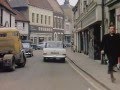 A Drive Through Beverley RE MASTERED c 1964 archive ref
 Wakefield in the early 60s
 No 21. Dashcam 1987 Style A Drive Through Normanton 5.5.87
 4k HDR | Wakefield West Yorkshire |June 2021 | city Centre walk
 Pontefract Castle - A Tour of the Keep Cellar
 Barnsley Canal Walk | Wakefield, West Yorkshire (Vlog #61)
 Wakefield History
 Leeds/Bradford Airport in the early 1970s
 Bradford Trolleybuses 1970, 1971 and 1972 - including the last day
 Mike N The Mechanics - Over My Shoulder Lyrics
 Wrenthorpe Remembered
 Horbury's Heritage QR code Trail