Flood risk for VIC, NZ monitors sub-tropical low
A significant rain event in Australia’s south east corner as NZ monitors a sub-tropical low - these are the two main features of the weather this week in our part of the world.
NZ - This week is much warmer and more settled compared to conditions a week ago, with easterlies, northerlies and westerlies the dominant airflows (no polar southerlies!). Some rain on the West Coast with heavy falls south of the glaciers, but elsewhere only a few showers are mostly in the forecast with most regions leaning drier. By Saturday a sub-tropical low from Tonga will be very near the North Island… for now it looks to remain just offshore, but it’s worth monitoring incase it does bring some wind and rain to northern NZ.
Australia - A significant rain event (yes, another one) for parts of VIC and TAS (and maybe some inland parts of NSW). Up to 150mm is possible with localised slips and flooding - and more rain for the Murray River catchment area to the east. Wettest day will be Thursday then spring-like windy (possibly gale) westerlies kick in by Friday with drier skies. The good news? High pressure is on the way this weekend.
Видео Flood risk for VIC, NZ monitors sub-tropical low канала WeatherWatchTV
Показать
Комментарии отсутствуют
Информация о видео
Другие видео канала
 Sunday Update: Mystery Creek, Waikato, weather June 12 - 15th
 Monday Update: Latest Mystery Creek weather forecast
 Inland thunderstorms this weekend in NZ - cold change for SE Aust.
 More windy westerlies with more Southern Ocean storms (04/12/20)
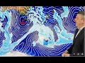 Warmer weekend in NZ, another cold snap next week
 Cooler nights, mild days as big anticyclone moves into NZ
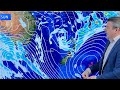 Tracking the weekend rain and showers
 NZ’s rain & sub-tropical warmth gives way to colder air next week
 South Island performs the ol’ switcharoo as North Island prepares for some rain (01/06/21)
 Heavy rain in Hawke’s Bay + NZ’s weekend weather
 A big high & a big low dominate our weather
 Wednesday update as Mystery Creek kicks off with dry skies (for now)
 The build up to Christmas has changeable weather
 Tuesday Update: Latest weather for Mystery Creek, Waikato
 Aussie: Rain returns to southern states! Sun returns to north.
 Aust 7 Day: Wintry in the SE, rain for dry SA, VIC, WA
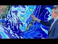 Stormy low to bring wind & rain to NZ Fri/Sat
 Large low looms for NZ - we break it down for you
 Cold changes this week, but sub-tropical warmth next week
 Hey NZ - it’s not all rain, some sunny dry weather is coming!