GIS in Airports | Best Practices from Esri and Arora Engineers
Between growing passenger volumes, a dynamic regulatory environment, maintenance and expansion of aging infrastructure, increased security concerns, and the constant need to grow revenues, the considerations of airport management can be staggering. This is why smart airports are turning to the power of GIS technology. GIS is founded on a location intelligence strategy that leads to better decision-making.
Join Esri and Arora Engineers to:
• Learn how to get started with GIS.
• Discuss common challenges and lessons learned.
• Discover resources required for success.
For more information, please visit: http://ow.ly/9kBz50y5Yaq
---------------------------------------------------------------------------------------------------
Follow us on Social Media!
Twitter: https://twitter.com/Esri
Facebook: https://facebook.com/EsriGIS
LinkedIn: https://www.linkedin.com/company/esri
Instagram: https://www.instagram.com/esrigram
The Science of Where: http://www.esri.com
Видео GIS in Airports | Best Practices from Esri and Arora Engineers канала Esri Industries
Показать
Комментарии отсутствуют
Информация о видео
Другие видео канала
 IBM Maximo Spatial, GIS and Mobility
 How Air Traffic Control Works
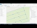 Introduction to the Utility Network for Water Utilities
 NVIDIA GTC 2021: How AI Enabled Video Analytics Improve Airport Operations Efficiency
 Web GIS Delivers Safety and Efficiency to Atlanta International Airport
 BIM and GIS: An Introduction
 Extracting Elevation Data from Google Earth
 Smart City Planning with ArcGIS Urban and CityEngine
 Ultra LongHaul flight during the Pandemic: Qatar Airways QSuite Airbus A350-1000 Doha to Los Angeles
 Private Pilot Tutorial 13: Airport Operations (Part 1 of 3)
 Geographic Information Systems (GIS): Dan Scollon at TEDxRedding
 Web GIS: Architectural Patterns & Practices
 Day at Work: GIS Analyst
 GIS Coordinate Reference Systems
 Deep Dive Into London Heathrow Airport | Heathrow | Spark
 10 Interview Questions for GIS Management Positions
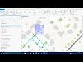 Getting to Know the Utility Network
 Military Tools for ArcGIS: Visibility for Analysts
 Creating Dynamic, Real-Time Maps with Operations Dashboard for ArcGIS
 ArcGIS Pro Model Builder | ArcGIS Mastery Course