- Популярные видео
- Авто
- Видео-блоги
- ДТП, аварии
- Для маленьких
- Еда, напитки
- Животные
- Закон и право
- Знаменитости
- Игры
- Искусство
- Комедии
- Красота, мода
- Кулинария, рецепты
- Люди
- Мото
- Музыка
- Мультфильмы
- Наука, технологии
- Новости
- Образование
- Политика
- Праздники
- Приколы
- Природа
- Происшествия
- Путешествия
- Развлечения
- Ржач
- Семья
- Сериалы
- Спорт
- Стиль жизни
- ТВ передачи
- Танцы
- Технологии
- Товары
- Ужасы
- Фильмы
- Шоу-бизнес
- Юмор
What Is the MrSID Decoding SDK? Complete Developer Guide.
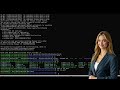
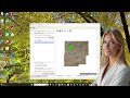
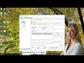
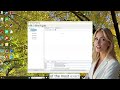
The MrSID Decoding SDK is a software development toolkit created by LizardTech that enables developers to efficiently decode and manage large raster image datasets such as satellite imagery, aerial photography, drone imagery, and scanned maps. It is designed for high-performance geospatial applications running on desktop, server, cloud, and mobile environments. The SDK allows applications to open MrSID files, decode compressed raster data, extract geospatial metadata, read specific image regions, support multiple zoom levels, and convert imagery for integration into GIS and mapping workflows.
The underlying MrSID format, which stands for Multi-Resolution Seamless Image Database, is a wavelet-based image compression technology developed specifically for handling massive geospatial raster datasets. It compresses very large image files while preserving visual quality and geographic accuracy. The format is widely used in GIS, remote sensing, defense, environmental monitoring, transportation planning, and urban development. One of its key advantages is the ability to access specific image regions and zoom levels quickly without loading the full image into memory, improving efficiency for large-scale mapping systems.
Developers use the MrSID Decoding SDK because traditional raster processing methods often struggle with enormous file sizes, heavy memory usage, slow rendering speeds, and limited scalability. The SDK addresses these problems through advanced decoding technology that enables selective image access, reduced bandwidth consumption, multi-resolution viewing, and efficient memory management. By decoding only the required portions of an image, applications can render imagery faster and perform more reliably, especially in enterprise GIS and cloud-based visualization systems.
The SDK includes several important technical features. It supports high-performance raster decoding, allowing enterprise applications to process large datasets quickly. Multi-resolution image support enables instant zooming without preprocessing additional image copies. Developers can also access geospatial metadata such as coordinate systems, projection information, image size, and resolution details directly through APIs. Additional capabilities include region-of-interest decoding, thread-safe multi-user processing, and support for extremely large satellite and aerial image files.
The MrSID Decoding SDK supports multiple raster formats and datasets depending on licensing and version configurations. These include Generation 2, 3, and 4 MrSID files, JPEG 2000 imagery, GeoTIFF workflows, and multi-band raster datasets. This flexibility allows developers to integrate the SDK into modern geospatial pipelines and enterprise imaging systems.
Technically, the SDK works by parsing MrSID file structures, identifying compression methods, resolution pyramids, metadata, and tile organization. Since MrSID uses wavelet compression technology, the SDK dynamically reconstructs image data based on the requested geographic region and resolution level. Developers can extract only the tiles required for visualization or analysis, reducing processing overhead and improving application responsiveness. The decoded imagery can then be integrated into GIS platforms, mapping tools, or visualization environments.
Compared to traditional raster handling methods that often load entire TIFF or RAW image files into memory, the MrSID SDK offers major performance advantages. It supports dynamic zooming, minimizes memory consumption, reduces storage requirements, and improves rendering performance. These benefits are particularly valuable for web GIS applications, cloud-based imagery systems, and real-time geospatial visualization platforms.
As imaging technologies continue advancing through high-resolution satellites, drones, LiDAR systems, and AI-driven geospatial analytics, the demand for scalable raster compression and decoding solutions continues to grow. The MrSID Decoding SDK provides developers with a reliable foundation for building responsive and scalable geospatial applications capable of handling massive raster datasets efficiently. Whether used for desktop GIS software, enterprise image services, or next-generation mapping systems, the SDK helps organizations manage modern raster image workflows without sacrificing performance or image quality.
https://www.lizardtech.com/post/what-is-the-mrsid-decoding-sdk-complete-developer-guide
Видео What Is the MrSID Decoding SDK? Complete Developer Guide. канала LizardTech (a GeoWGS84 Company)
Комментарии отсутствуют
Информация о видео
20 мая 2026 г. 2:59:16
00:02:01
Другие видео канала