- Популярные видео
- Авто
- Видео-блоги
- ДТП, аварии
- Для маленьких
- Еда, напитки
- Животные
- Закон и право
- Знаменитости
- Игры
- Искусство
- Комедии
- Красота, мода
- Кулинария, рецепты
- Люди
- Мото
- Музыка
- Мультфильмы
- Наука, технологии
- Новости
- Образование
- Политика
- Праздники
- Приколы
- Природа
- Происшествия
- Путешествия
- Развлечения
- Ржач
- Семья
- Сериалы
- Спорт
- Стиль жизни
- ТВ передачи
- Танцы
- Технологии
- Товары
- Ужасы
- Фильмы
- Шоу-бизнес
- Юмор
Video 4- Compressing Satellite, Aerial, and Drone Imagery to MrSID with LizardTech GeoExpress
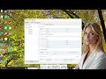
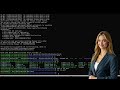
Now I want to show you there's a couple of different options for the GeoExpress Software.
This version that I have right now is an unlimited version. So you can compress as much data
as you want. and this is cartridge available. There's also an option for 100 megabytes. So, if
you have a 100 megabyte cartridge, it's showing you that six gigabytes of that cartridge will
be used.
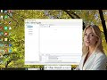
And now this six gigabytes that'll be used by the job is uncompressed GeoTiff. And I say that
because a lot of the raster imagery that you work with may have some compression to it. It
may have a TIFF extension, but it may be a JPEG and TIFF. It might be an LZW TIFF file.
And so this will show the compressed version. So you may have a JPEG file and it might be 8
megabytes. And to compress it to the GeoTiff or to the MrSID file, it uncompresses it to a 50
megabyte GeoTiff file. So that's just something to keep in mind when you're doing that.
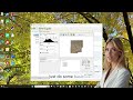
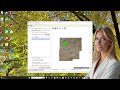
And also on the mosaic option there's some advanced features. One feature I want to show
you is use world files only. By default, the GeoExpress software reads the header information
in the raster image. Sometimes you get a raster image where somebody wiped out the header
information. Maybe they saved it in Adobe Photoshop or something like that. If you still have
that world file, then you can still compress it and assign that projection and datum to it. Some
people also think using the world file is more accurate than reading the header information. I
disagree. I think either way is just as accurate. So for this mosaic, there's some output
options. One of them is to enable multi-resolution.
So if you have several tiles you want to put together and they're different resolutions just
check that box and by default it will go to the smallest resolution. But you can also set the
output resolution.
Видео Video 4- Compressing Satellite, Aerial, and Drone Imagery to MrSID with LizardTech GeoExpress канала LizardTech (a GeoWGS84 Company)
This version that I have right now is an unlimited version. So you can compress as much data
as you want. and this is cartridge available. There's also an option for 100 megabytes. So, if
you have a 100 megabyte cartridge, it's showing you that six gigabytes of that cartridge will
be used.
And now this six gigabytes that'll be used by the job is uncompressed GeoTiff. And I say that
because a lot of the raster imagery that you work with may have some compression to it. It
may have a TIFF extension, but it may be a JPEG and TIFF. It might be an LZW TIFF file.
And so this will show the compressed version. So you may have a JPEG file and it might be 8
megabytes. And to compress it to the GeoTiff or to the MrSID file, it uncompresses it to a 50
megabyte GeoTiff file. So that's just something to keep in mind when you're doing that.
And also on the mosaic option there's some advanced features. One feature I want to show
you is use world files only. By default, the GeoExpress software reads the header information
in the raster image. Sometimes you get a raster image where somebody wiped out the header
information. Maybe they saved it in Adobe Photoshop or something like that. If you still have
that world file, then you can still compress it and assign that projection and datum to it. Some
people also think using the world file is more accurate than reading the header information. I
disagree. I think either way is just as accurate. So for this mosaic, there's some output
options. One of them is to enable multi-resolution.
So if you have several tiles you want to put together and they're different resolutions just
check that box and by default it will go to the smallest resolution. But you can also set the
output resolution.
Видео Video 4- Compressing Satellite, Aerial, and Drone Imagery to MrSID with LizardTech GeoExpress канала LizardTech (a GeoWGS84 Company)
Комментарии отсутствуют
Информация о видео
3 февраля 2026 г. 1:42:01
00:02:27
Другие видео канала