- Популярные видео
- Авто
- Видео-блоги
- ДТП, аварии
- Для маленьких
- Еда, напитки
- Животные
- Закон и право
- Знаменитости
- Игры
- Искусство
- Комедии
- Красота, мода
- Кулинария, рецепты
- Люди
- Мото
- Музыка
- Мультфильмы
- Наука, технологии
- Новости
- Образование
- Политика
- Праздники
- Приколы
- Природа
- Происшествия
- Путешествия
- Развлечения
- Ржач
- Семья
- Сериалы
- Спорт
- Стиль жизни
- ТВ передачи
- Танцы
- Технологии
- Товары
- Ужасы
- Фильмы
- Шоу-бизнес
- Юмор
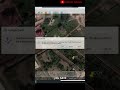
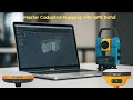
3D Survey 3.0.1: A Complete Guide for drone image processing with Ground Control Points!
Unlock the full potential of drone mapping with this complete guide on processing images in 3D Survey using Ground Control Points (GCPs)!
Whether you’re a professional surveyor or a drone enthusiast, this video covers everything you need to know to achieve high-accuracy results.
By combining drone imagery with GCPs, 3D Survey software allows you to create precise, georeferenced 3D models perfect for surveying, construction, and environmental analysis. 🚁📍✨
In this video, we’ll explore:
- Setting up Ground Control Points (GCPs) for accurate georeferencing
- Capturing drone images with ideal overlap for 3D modeling
- Importing and processing images in 3D Survey software
- Integrating GCPs to anchor your model to real-world coordinates
- Generating and exporting 3D models for GIS and CAD applications
Follow along to see how easy it is to improve your drone mapping accuracy with GCPs in 3D Survey. Ready to take your drone surveying to the next level?
Hit play, and don’t forget to subscribe for more tutorials on drone mapping, surveying software, and GIS techniques! 🎥💻
Drone Image Files: https://drive.google.com/file/d/1XT4GLQhV4zW-lMCwh0BEtWI-mqeOi599/view?usp=drive_link
Ground Control File: https://drive.google.com/file/d/1IhO8J9TgMBTRvXXNblrkkmbKDWmTDAsC/view?usp=drive_link
00:00 Introduction
00:40 Launcing, Displaying & Loading Drone Images
01:57 Bundle Adjustment
03:10 Orientate
05:43 3D Reconstruction
06:13 Mesh
06:23 Orthophoto
06:52 Conclusion
#3DSurvey #DroneMapping #GroundControlPoints #GCP #3DModeling #Surveying #DroneSurveying
Видео 3D Survey 3.0.1: A Complete Guide for drone image processing with Ground Control Points! канала Nexxis Tutorials
3DSurvey aerial mapping image processing gis DroneMapping GroundControlPoints GCP 3DModeling DroneSurveying Surveying photogrammetry dji aerial survey remote sensing ground control points drone ground control point drone survey image processing with ground control points ground control points for drone mapping drone images processing tutorial drone survey accuracy setting ground control points uav image processing how to process drone images survey processing
Комментарии отсутствуют
Информация о видео
7 ноября 2024 г. 21:00:28
00:07:36
Другие видео канала