How to use the DJI Zenmuse L1 LiDAR and Matrice 300
Camille goes over the best practices for flying the DJI Matrice 300 and Zenmuse L1 LiDAR. We cover how to plan a LiDAR mission in the DJI Pilot app, infield data collection, and how to process L1 data in DJI Terra. Learn more about the Lidar360 software suite: https://candrone.com/pages/lidar-software. Visit our website to rent or buy the DJI L1 Lidar: www.candrone.com
Contact us at support@candrone.com or call 1-888-461-5742
Follow us on LinkedIn to stay up to date with the latest LiDAR technology: https://www.linkedin.com/company/candrone
Видео How to use the DJI Zenmuse L1 LiDAR and Matrice 300 канала CANDRONE
Contact us at support@candrone.com or call 1-888-461-5742
Follow us on LinkedIn to stay up to date with the latest LiDAR technology: https://www.linkedin.com/company/candrone
Видео How to use the DJI Zenmuse L1 LiDAR and Matrice 300 канала CANDRONE
Показать
Комментарии отсутствуют
Информация о видео
Другие видео канала
 Don't buy the DJI Zenmuse L1 until you've seen this! ROCK vs RIEGL vs DJI
 DJI Matrice 300 RTK + L1 **FULL DEMO**
 DJI LIDAR Zenmuse L1, Phantom 4 RTK & DJI Terra (TESTED WITH PERTAMINA IN INDONESIA)
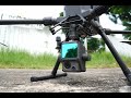 Terrain Mapping Demo with DJI Zenmuse L1
 DJI Matrice 300 RTK and L1 Lidar Solution for Aerial Surveying | Project Workflow
![Contour lines at bare earth [with Zenmuse L1]](https://i.ytimg.com/vi/ClTtmWF45vY/default.jpg) Contour lines at bare earth [with Zenmuse L1]
Contour lines at bare earth [with Zenmuse L1] DJI Zenmuse L1 - In the Field
 Matrice 300 RTK | How to Fly
 DJI Zenmuse L1 - Workflow
 DJI Zenmuse L1 & P1 - WORKFLOW WEBINAR
 City 3D model: Metashape + DJI Zenmuse P1.
 What a surveyor thinks about the DJI P1 REVIEW
 Land Surveying with Drone LiDAR | On the job
 DJI Inspire 2 LiDAR Drone - ROCK R1A
 1. HOW TO Setup LiAirV Lidar Mount to Matrice 200 Series
 DJI Zenmuse L1 - What everyone wants to know
 This LiDAR Drone does it ALL + special reveal at the end!
 DJI Zenmuse L1 - forest
 DJI Matrice 300 & H20T Thermal Drone Camera | Smart Track, Pin Point + Feature Review
 New DJI Zenmuse L1 LiDAR - Real-Time 3D data Review