Arcpro building foot print and deep learning tool
ArcGIS pro deep learning tool can use to extract building footprint automatically. In this demo it is showing how to extract building footprint using deep learning tool in ArcGIS pro. For that you need to download building extraction deep learning package file from ArcGIS living atlas and you also need to download Deep learning libraries installer from GitHub. Below link is shared from where you can get both that.
Building Footprint Extraction - USA
https://livingatlas.arcgis.com/en/browse/#d=2&q=building%20extraction%20model
Deep Learning Libraries Installer for ArcGIS Pro 2.6
https://github.com/Esri/deep-learning-frameworks
This demo give you brief idea how to use deep learning tool in ArcGIS pro. #ArcGIS Pro# Deep learning# Building Extraction# satellite data processing# Remote sensing#
Видео Arcpro building foot print and deep learning tool канала Space, Remote sensing and GIS
Показать
Комментарии отсутствуют
Информация о видео
17 декабря 2021 г. 20:40:19
00:13:28
Другие видео канала
 Forest fire assessment using indices and change detection tool in ArcGIS Pro
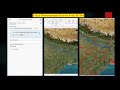 How to trace downstream in ArcGIS Pro
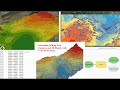 UTM excel DGPS data conversion for mining
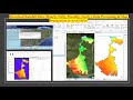 Download Rainfall Data Hourly, Daily, Monthly, Yearly, Data Processing & Map Preparation in ArcGISPr
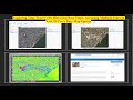 Exploring Historical High-Resolution Images with ArcGIS Pro: Identifying Changes in Varanasi City
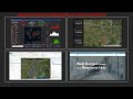 Updating ArcGIS hub and dashboard from ArcGIS and ArcGIS Pro
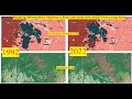 Mapping Deforestation Patterns in Brazil and India with ArcGIS Pro's Living Atlas
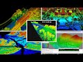 ENVI LIDAR
 River Stream Order Map in ArcGIS Pro
 Use Neighborhood Explorer tool in ArcGIS Pro
 Download Water body data (Shapefile) Lakes, River, Wetland of any Location and open it in ArcGIS Pro
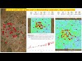 Extract multi value points and Co Relationship estimation, chart preparation
 Watershed/ catchment extraction in ArcGIS Pro
 ACE Target Detection over Hyperspectral Data
 ENVI Crop science tool for precision agriculture
 NDVI with ArcPy for Python Developers using ArcGIS Pro
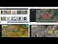 ESRI imagery web-apps and use Sentinel-2 and Landsat Imagery with ArcGIS Pro
 Captivating Image of Cyclone Biparjoy Reveals Unprecedented Details: Download and Analyze
 Roop kund Trek base point video created using ArcGIS Pro Animation tool
 Extract Elevation Values from DEM
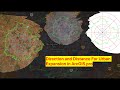 Direction and Distance for urban expansion in ArcGIS Pro