DJI Mavic 2 Pro Drone 3D Model - Pix4D, Drone Deploy, Maps Made Easy, & Photoscan comparison
Today’s video highlights a very simple 3D Model of a new home in Arizona. A DJI Mavic 2 Pro drone was used to orbit the home and take 49 images to be used in the 3D Model creation. The model was rendered with Pix4D Cloud and the desktop Pix4D Model software, Drone Deploy’s cloud, Maps Made Easy Cloud, and Photoscan Standard desktop solution. You’ll notice right away there are differences between each software package even thought the same exact data was used in all of the software packages.
Bottom line? 3D Modeling results will vary from software package to software package.
“Beginners DJI Ground Station Pro” class launched on July 25th, 2020. If you’re interested in capturing data for 2D & 3D Models with an iPad this is the course for you! And right now visitors to this channel can get the class for 40% off by following this link. - https://tinyurl.com/y2h7g52n
New to Drone 3D Modeling and Mapping? Check out my latest online course for beginners! We all have to start somewhere, and this is a hot topic in the Drone Industry: https://bit.ly/2qWR0zE
Learn Lightroom from the ground up for only $10. Improve your workflow, photo management, and editing with Lightroom. https://bit.ly/2NDHSNj
Drone Photography and Image Editing For Beginners, more than 50% off for visitors to this channel! A class for beginners to drone photography and editing with Lightroom, Aurora HDR, Luminar, & Photoshop. 8 hours of course time including more than 2 hours of adobe lightroom tutorial. https://bit.ly/2NPbB65
Learn to build your own website with Wordpress and X Theme: https://bit.ly/2QAoejP
Follow me on Instagram at:
https://www.instagram.com/livingintin/
Follow my daily audio podcast (Monday - Friday) at: https://anchor.fm/the-airstream-chronicles
Like the music tracks on this channel? It's licensed through Soundstripe.com
Click below to visit Soundstripe, where we get all of our audio tracks!
https://soundstripe.grsm.io/RichardCharpentier
Looking to support this channel so I can provide more mobile tech and mobile living videos? I'm using Patreon and you can find my Patreon Page at the link below:
https://www.patreon.com/RichCharpentier
Видео DJI Mavic 2 Pro Drone 3D Model - Pix4D, Drone Deploy, Maps Made Easy, & Photoscan comparison канала Rich Charpentier
Показать
Комментарии отсутствуют
Информация о видео
Другие видео канала
 Drone Deploy Mapping Demo Tutorial | DJI Mavic Pro
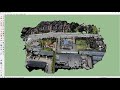 How to create 3D environment models from drone images
 Aerial Photogrammetry Explained - Create 3D Models With Drone Photos
 Can the DJI Mavic 2 Pro Be Used for Commercial Drone Work?
 DJI Ground Station Pro and the Mavic 2 Pro. 3D mapping modeling
 Mavic 2 Pro 3D Mapping Modeling - Pix4D Capture, Photoscan, SketchFab, & Drone Deploy
 How To Create a 3D Model Using DroneDeploy
 Drone 3D Model start to finish - Mavic 2 Pro, Litchi, Kyno, and Agisoft's Metashape
 How to make a 3D model with a drone FOR FREE
 Job Shadow: Drone survey & stockpile volume measurements
 PIX4D Vs. Agisoft Metashape-3D Modeling
 DJI Mavic Air 2 Mapping Mission - Dronelink + Maps Made Easy
 DJI MAVIC 2 PRO - ALL Intelligent Flight Modes - EXPLAINED!
 Photogrammetry/Drone Mapping mistakes you should avoid.
 Parrot Anafi Work
 DroneDeploy Is Easier to Use. Why Should I Go for Pix4D?
 Processing Drone Images with GCPs using Pix4D Mapper
 RoofSnap vs DroneDeploy - What Is The Best Roof Measuring App?
 Getting Started With DroneDeploy
 Drone Modeling With Map Pilot Pro - Part of our latest class update