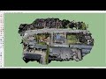
Processing Drone Images with GCPs using Pix4D Mapper
This is a video tutorial on how to process drone images to make accurate map products using Pix4D Mapper software.
The sample data set used in this video can be found in : https://drive.google.com/file/d/1SV4VWm2TssNAaP79AAJoBZA9bqGMiVjt/view?usp=sharing
Видео Processing Drone Images with GCPs using Pix4D Mapper канала Sasanka Madawalagama
The sample data set used in this video can be found in : https://drive.google.com/file/d/1SV4VWm2TssNAaP79AAJoBZA9bqGMiVjt/view?usp=sharing
Видео Processing Drone Images with GCPs using Pix4D Mapper канала Sasanka Madawalagama
Показать
Комментарии отсутствуют
Информация о видео
Другие видео канала
 GCP's 101 | Ground Control Points Complete Guide | How to collect and process for Drone Mapping
 Pix4D Webinar: Pix4Dmapper Outputs in AutoCAD and ArcGIS
 Drone Data Processing for Surveyors
 DroneCamp 2020: Introduction to Multispectral Image Processing with Pix4D Mapper
 How to create 3D environment models from drone images
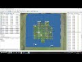 Georeferencing in Agisoft Metashape using GCPs
 How to use Pix4D Capture & Pix4D Cloud
 Drone Deploy Mapping Demo Tutorial | DJI Mavic Pro
 Process drone photos using Carlson Photo Capture and Precision 3D
 Pix4D Mapper - Generating a Digital Terrain Model
 More accurate maps and 3D models with tie points: Pix4Dmapper Video Tutorial 4
 How to get accuracy in Drone / UAS Mapping with Pix4D: What You Need to Know
 TUTORIAL PIX4D
 Accurate georeferencing in Pix4D - Pix4Dmapper Video Tutorial 2
 Photogrammetry/Drone Mapping mistakes you should avoid.
 TUTORIAL Agisoft Metashape - orthophoto and DSM generation (with GCPs)
 Webinar Pix4d mapper: Mapas georeferenciados y modelos 3D de alta precisión desde imágenes
 Pix4D Webinar: 3D Mesh (2015)
 DJI Phantom 4 RTK | Mission Planning & Setup with the D-RTK 2 Base Station