PyCon.DE 2018: Satellite Image Segmentation Photovoltaic Potential Estimation - Johannes Oos
The used technologies are python based and include: MongoDB tensorflow Flask google.cloud python API
A dataset of labelled satellite images is created. Several networks are trained and tested on this dataset. The network is deployed on a production server.
The results of the classification/segmentaion are used to feed python based photovotlaic simulation libaries. The output is displayed and the results (the potential) evaluated.
Видео PyCon.DE 2018: Satellite Image Segmentation Photovoltaic Potential Estimation - Johannes Oos канала PyConDE
Показать
Комментарии отсутствуют
Информация о видео
Другие видео канала
 Mark Smith: Stupid Things I've Done With Python
 Lessons Learned Training Object Detection Models on Satellite Imagery
 78 - Image Segmentation using U-Net - Part 6 (Running the code and understanding results)
 Artificial Intelligence in Space: Change Detection with Radar Satellite Data
 Simple Steps to Download Many Scenes of Sentinel Satellite Imagery from Copernicus Hub
 K-means & Image Segmentation - Computerphile
 Amazon Rainforest Satellite Image Classification using Convolutional Neural Networks
 Lecture 11 | Detection and Segmentation
 Create training and test data for Object-Based Image Analysis
 Basic ceramic rooftop extraction in Remote Sensing
 44 EO Applications-1, CNN based building footprint detection from remote sensing imagery
 Johannes Wachs - Analyzing Networks In Python
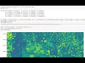 NDVI calculation from Landsat8 images with Python 3 and Rasterio - Tutorial
 HISTORICAL AERIALS AND MAPS TUTORIAL
 Fully Convolutional Networks for Image Segmentation | SciPy 2017 | Daniil Pakhomov
 Python For Humans
 How to Make an Image Classifier - Intro to Deep Learning #6
 How Computers See the Earth: A ML Approach to Understanding Satellite Imagery (Cloud Next '18)
 How to Make a Simple Tensorflow Speech Recognizer
 Christian Heimes: Python 3.11 in the Web Browser - A Journey (Keynote)