Lessons Learned Training Object Detection Models on Satellite Imagery
Roger FONG Computer Vision Scientists at Picterra
SwissAI Machine Learning Meetup 2018.10.15
Some of the addressed themes:
1. How Can We Use Satellite and Drone Images?
2. What Models And Datasets Can We Use to Learn How to Label Objects On Satellite Images?
3. What Is YOLO - You Only Look Once, Real-Time Object Detection Model
4. What Are The Solutions to Common Problems When Analysing Satellite Images with YOLO?
Abstract: Satellite imagery provides a wealth of visual information but without the proper tools, it can be daunting to understand. Our mission at Picterra is to provide deep learning empowered tools that are capable of analyzing these images and providing valuable information to our customers. In this talk, we will focus on the challenges of object detection from satellite imagery and our approach to the problem. https://picterra.ch
## Organizers ##
SwissAI Machine Learning Meetup is one of the larges AI meetups in Switzerland, with regular meetings, great speakers invited from academia and industry and over 1200 members from Lake Geneva Area. For more information and future events visit https://www.SwissAI.org
Pawel Rosikiewicz, Founder of SwissAI,, Event Organiser
https://www.linkedin.com/in/pawel-rosikiewicz/
Juraj Korček, Data Scientist and ML Engineer, Event co-organiser and Interviews
https://www.linkedin.com/in/korcekjuraj/
Ieva Vaišnoraitė-Navikienė, ML Engineer, Event co-organiser
https://www.linkedin.com/in/ieva-vaisnoraite-navikiene/
Matteo Pagliardini, Senior ML Engineer, Event co-organiser
https://www.linkedin.com/in/matteo-pagliardini/
Clement Charollais, EPFL, Camera Operator and Movie Editing
https://www.linkedin.com/in/clément-charollais-b7209177/
Sponsors:
École Polytechnique Fédérale de Lausanne (EPFL)
https://www.epfl.ch
Innovaoud
https://www.innovaud.ch
SamurAI - Data Science Services
https://www.samurai.team
Видео Lessons Learned Training Object Detection Models on Satellite Imagery канала SwissAI
Показать
Комментарии отсутствуют
Информация о видео
Другие видео канала
 When deep learning meets satellite imagery
 The NASA-ISRO Synthetic Aperture Radar (NISAR) Mission
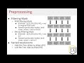 Real-Time Spatiotemporal Air Pollution Prediction with Deep ConvLSTM via Satellite Image Analysis
 Grad-CAM class activation visualization - Keras Code Examples
 Machine Learning and Satellite Imagery overview
 RUS webinar: Rapid Landslide Detection with Sentinel-1 - HAZA07
 Dominating an Online Game with Object Detection Using OpenCV - Template Matching.
 Training and Validating Object Detectors
 SAR Theory
 Spy Satellite Expert Explains How to Analyze Satellite Imagery | WIRED
 Vehicle Detection from Satellite Images using Deep Learning
 Yolov4 Object Detection - How it Works & Why it's So Amazing! | OpenCV Python | Computer Vision
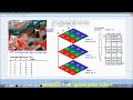 Lec-1: Image Classifier Using Machine Learning, Neural Networks-For Medical/Satellite Images-Part 1
 Scalable Computing in Oceanography with Deepak Cherian
 A Recommender System For Healthy Behaviour Change
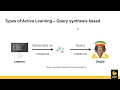 Active learning for deep detection neural networks
 Synthetic Aperture Radars (SAR) Technology and Applications
 Random Forest Image Classification in Python
 CV3DST - Object Detection 1
 Tensorflow Object Detection with Tensorflow 2: Creating a custom model