Methane Emissions from Wetlands
Methane is an important greenhouse gas that contributes substantially to global warming. On a molecule by molecule basis, methane is much more efficient at trapping heat than carbon dioxide, the main driver of warming. Though human activities, including agriculture, oil and natural gas production and use, and waste disposal, collectively contribute the majority of methane to the atmosphere, about a third of total methane emissions comes from wetlands. Wetland habitats are filled with things like waterlogged soils and permafrost, which makes them sizable carbon sinks. However, as the climate changes, these carbon-rich soils are vulnerable to flooding and to rising temperatures, which can release more carbon to the atmosphere in the form of methane. Understanding methane emissions from natural sources like wetlands is critically important to scientists and policymakers who are working to ensure that changes in natural systems don’t counteract progress in combatting climate change made by reducing emissions from human activities.
This animation shows estimates of wetland methane emissions produced by the Lund–Potsdam–Jena Dynamic Global Vegetation Model (LPJ-DGVM) Wald Schnee und Landscaft version (LPJ-wsl). LPJ-wsl is a prognostic model, meaning that it can be used to simulate future changes in wetland emissions and independently verified with remote sensing data products. The model includes a complex, topography dependent model of near surface hydrology, and a permafrost and dynamic snow model, allowing it to produce realistic distributions of inundated areas. Highlighted areas show concentrated methane sources from tropical and high latitude ecosystems. The LPJ-wsl model is regularly used in conjunction with NASA’s GEOS model to simulate the impact of wetlands and other methane sources on atmospheric methane concentrations, compare against satellite and airborne data, and to improve understanding and prediction of wetland emissions.
For more details visit the SVS page: https://svs.gsfc.nasa.gov/5054
Видео Methane Emissions from Wetlands канала NASA Scientific Visualization Studio
Показать
Комментарии отсутствуют
Информация о видео
7 июня 2023 г. 23:33:34
00:00:31
Другие видео канала
 Some Like It Hot! by Tibor Kremic
 Alex Young: Sun and Moon Together Again: Helio Science from the Moon
 A Quarter Century US Forest Disturbance History from Landsat – the NAFD-NEX Products
 Earth Day 2020: Sea Surface Temperature (SST) from January 2016 through March 2020
 Curating NASA's Extraterrestrial Samples from Past and Future Sample Return Missions
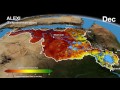 The Distributed Water Balance of the Nile Basin
 Sunny with a Chance of Space Storms by Alex Young
 Greenland's Jakobshavn Region: Simulated Ice Sheet Response Scenario RCP 8.5: 2008 - 2300
 Paula Bontempi: An Overview of Earth Science at NASA
 AGU 2023 Tuesday Introductory Remarks from AGU & NASA
 Anna Barth: Listening to Eruption Dynamics at Lone Star Gyser, Using Multivariate Sonification
 Arctic Sea Ice Minimum 2022.
 From Slime to Solutions: Monitoring water quality and cyanobacteria from space
 Explore the Literature in the New ADS
 Future of infectious diseases: How Earth observations can help predict next pandemics?
 IceFlow: Harmonizing NASA ICESat, IceBridge, and ICESat-2 data
 EXPORTS
 Jakobshavn Regional View of Simulated Greenland Ice Sheet Response Scenario - RCP 2.6: 2008 - 2300
 Warning! Local Tsunami Alert from GPS Array by Dara Goldberg
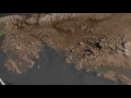 Antarctic Bedrock
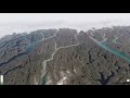 The Connected Solar System SSTP