SARAi E-skwela on Drought from Space: Utilizing satellite data to monitor drought in the Philippines
NOTE: Please email us at project.sarai.uplb@gmail.com if you want to have a copy of this video or if you will use this video for a certain purpose. This is for our documentation. Thank you very much!
Drought and Crop Assessment Forecasting (DCAF) utilizes satellite images to generate maps that can be used to generate drought index suitable for Philippine condition. Through DCAF, we can now predict drought occurrences six months ahead, assess crop yield, and mitigate severe effects drought in the Philippines.
Видео SARAi E-skwela on Drought from Space: Utilizing satellite data to monitor drought in the Philippines канала Project SARAi
Показать
Комментарии отсутствуют
Информация о видео
Другие видео канала
 CFS Interview 1 080315
 SARAi E-skwela on CAPHE and Coffee Processing
 Know more about Project SARAI
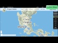 SARAI Interactive Maps and Real-time Data
 A Walkthrough to Project SARAI by Dr. Maria Victoria O. Espaldon (SARAI Program Leader)
 SARAi E-skwela Season 2 Episode 1: Recommended Agricultural Practices for Coconut
 SPIDTECH Introductory Video (Filipino)
 SARAI analysis of Taal Ashfall
 SARAi E-skwela S2 Episode 3 - Gabay sa Produksyon ng Soybean
 SARAi E-skwela on Satellite Remote Sensing: A smarter approach for agricultural monitoring
 CSU Training
 SARAI Taal Ashfall Crop Advisory
 An Introduction: SARAI Real Time Weather Monitoring with Prof. Nelio Altoveros of IMSP, UPLB
 SARAi E-skwela - Improving Smallholder Access to Inst'l Markets by Training on Cacao Primary Process
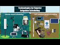 SARAi E-skwela on Smarter Technologies for Crop Water Management
 An Introduction: SARAI WAISS
 Cacao Primary Processing Technologies NSTW Davao Presentation
 SARAI SPIDTECH how to FILIPINO
 SARAI SPIDTECH how to ENGLISH
 Suitability Maps WARAY