Hawaii Kilauea Volcano Halemaumau Lava Lake Overflight and Drone Videos 🌋- 1/8/2021
This January 8th, 2021 Kilauea Volcano Eruptions update presentation video contains two new USGS aerial video and several with additionally improvements such as motion enlargements, sharpness increase, vibration reduction and additional sound effects enhanced videos. The media obtained from USGS and Google Earth with some of the details from; USGS at https://www.usgs.gov/volcanoes/kilauea/photo-video-chronology and earthquakes data. According to the USGS HVO Scientists, the lava lake is still rising it is around 194 m (636 ft) deep. The lava lake was 191 m (623 ft) deep Monday afternoon (Jan. 4) and had a volume of about 26 million cubic meters (34 million cubic yards). The most recent thermal map (Dec. 30) provided the lake dimensions as 800 by 530 m (875 by 580 yds) for a total area of 33 ha (82 acres) (https://www.usgs.gov/maps/december-30-2020-k-lauea-summit-eruption-thermal-map). The lake is now perched about a meter (yard) above its narrow edges as measured Sunday morning (Jan. 3); overflows onto the narrow edge slowly elevated a low wall around the lake similar to the wall around an above-ground swimming pool.
The 11 smaller islands moved a bit but remained in the east end of the lake. The main island measured about 250 m (820 ft) in length, 135 m (440 ft) in width, and about 3 ha (7 acres) in area based on the Dec. 30 thermal map. Measurements Friday afternoon (Jan. 1) showed that the island surface was about 6 m (20 ft) above the lake surface. Yesterday afternoon, (Jan. 4), the island was measured as 1-2 m (1-2 yds) higher above the lake surface.
HVO scientists collect detailed data to assess hazards and understand how the eruption is evolving at Kīlauea's summit, all of which are shared with the National Park Service and emergency managers. Access to this area is by permission from, and in coordination with, Hawai‘i Volcanoes National Park. HVO scientists monitor the eruption from within an area of Hawai‘i Volcanoes National Park that remains closed to the public for safety reasons. Associated USGS thermal imaging, illustration maps, time lapse and overflight video with more pronounced helicopter and wind sound are also provided.
It is very exciting to see that Hawaii Kilauea Volcano Halemaumau lava lake is back and looks like much bigger than before. Hopefully Visitors of the Volcano National Park will be able to enjoy these amazing views with their own eyes.
January 2021 is Hawaiʻi Island's 12th annual Volcano Awareness Month.
According to the USGS Hawaii Volcano Observatory HVO website;
https://volcanoes.usgs.gov/volcanoes/kilauea/status.html
The lava lake has been rising approximately several meters (yards) an hour since the eruption began. The current lava lake exhibits a circulating perimeter, but stagnant center.
The event has been accompanied by only moderate amounts of deformation, indicating deflation of a magma reservoir under Halema'uma'u. Rates of tilting have decreased slightly since the beginning of the eruption.
Increased rates of seismicity in the summit region continue. Some of these earthquakes may be felt. A magnitude-4.4 earthquake located beneath Kīlauea Volcano's south flank occurred on Sunday, December 20, at 10:36 p.m. HST.
Visitors to the Hawai'i Volcanoes National Park should note that under southerly (non-trade) wind conditions, rockfalls and explosions can result in a dusting of powdery to gritty ash composed of volcanic glass and rock fragments.
Here is my Lava Flow Rate calculation;
In reference to Beginning 2020-12-20 21:30 HST and the Summit Eruption Reference Map 2020-12-27 16:00 HST stats with 5.6 Billion Gallons, and with Time Difference of 6 days, 18 hours, 30 minutes or 162.5 hours or 9750 minutes or 585000 seconds; Therefore 5.6 billion gallons of lava / 585000 seconds = 9572.6 gallons of lava per second (36236.2 liters / second) average flow for approximately the first week. Lava specific weight is about 3100 kg/m3 therefore flow rate is ~112 metric tons per second.
This presentation may contain unintentional errors or audio visual enhancements to improve perception. For official data and media please refer to the USGS.gov website. Attribution: Volcano Hazards Program Office, Hawaiian Volcano Observatory, Kīlauea
ANR Music, and special effect sounds from YouTube Audio Library for creators.
Видео Hawaii Kilauea Volcano Halemaumau Lava Lake Overflight and Drone Videos 🌋- 1/8/2021 канала Volkan Yuksel
Показать
Комментарии отсутствуют
Информация о видео
Другие видео канала
 Flight from Mont Blanc, France to Turin, Italy area - 4K
 Orchids Greenhouse Tour from South Florida
 Rewrite The Stars at Celebrity BEYOND
 Drive Thru Scenic Needles Highway to Sylvan Lake and the Needles Eye Tunnel at Custer State Park, SD
 Stunning Bryce Canyon National Park of Utah
 Walking Around Westlake, Florida and a Model Home Tour
 Atlantis Paradise Island, Bahamas before Hurricane
 Hawaii Kilauea Volcano Halemaumau Crater Lake Eruption Flight Video Update 🌋- 10/1/2021
 The Essential Driving Around West Palm Beach and Palm Beach, Florida Update
 Anhinga Bird - 4K
 Hawaii Mauna Loa Volcano Eruption Update 12/03/2022
 LG V20 test video at Antarctica - 4K
 Walking Around World Famous Worth Ave and Downtown Palm Beach, Florida - 4K
 Prince's Purple Rain Live Cover at Celebrity BEYOND
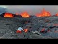 Hawaii Kilauea Volcano September 2023 Eruption Update
 Hawaii Mauna Loa Volcano Eruption Update 12/02/2022
 Mountain on the Moon
 Spectacular Fall Season Drive Near Aspen, Colorado
 Florida Coastal Drive - Palm Beach - 4K
 Driving From Jupiter island to Singer Island via Juno Beach, Florida
 Flying and Walking Around Farley Hill Barbados