- Популярные видео
- Авто
- Видео-блоги
- ДТП, аварии
- Для маленьких
- Еда, напитки
- Животные
- Закон и право
- Знаменитости
- Игры
- Искусство
- Комедии
- Красота, мода
- Кулинария, рецепты
- Люди
- Мото
- Музыка
- Мультфильмы
- Наука, технологии
- Новости
- Образование
- Политика
- Праздники
- Приколы
- Природа
- Происшествия
- Путешествия
- Развлечения
- Ржач
- Семья
- Сериалы
- Спорт
- Стиль жизни
- ТВ передачи
- Танцы
- Технологии
- Товары
- Ужасы
- Фильмы
- Шоу-бизнес
- Юмор
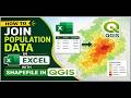
Radiometric Calibration of Satellite Images Tutorial Overview is out #remotesensing #mapping
#RadiometricCalibration #SatelliteImagery #RemoteSensing #ENVITutorial #ImageProcessing #Landsat #GIS
Buy me a coffee here: https://buymeacoffee.com/geojay
For business and enquiries: WhatsApp+2347065365193 or Email: geojaygis@gmail.com
WhatsApp Group: https://chat.whatsapp.com/CvvLBo7YisgIClQgzL7WOa
Facebook Group: https://www.facebook.com/share/g/1Fn4oQzn1L/
Radiometric Calibration, Satellite Imagery, Remote Sensing, ENVI Tutorial, Image Processing, Landsat Calibration, Digital Numbers, DN to Radiance, Radiance to Reflectance, Top of Atmosphere, TOA Reflectance, Surface Reflectance, Satellite Data Preprocessing, Sensor Calibration, Multispectral Analysis, Landsat 8, Landsat 9, Sentinel 2, Landsat 7, ETM+, OLI, TIRS, Metadata File, MTL File, Radiometric Correction, Atmospheric Correction, FLAASH, QUAC, Dark Object Subtraction, DOS1, Image Enhancement, Spectral Analysis, Band Math, GIS Tutorial, Geospatial Data, Earth Observation, NASA, USGS, EarthExplorer, Gain and Offset, Solar Irradiance, Sun Elevation, Earth-Sun Distance, Thermal Calibration, Brightness Temperature, Kelvin, Celsius, Satellite Sensor, Optical Remote Sensing, Digital Image Processing, Geomatics, Spatial Analysis, Data Accuracy, Scientific Computing, Remote Sensing Software, NV5 Geospatial, Harris ENVI, ENVI 6.0, ENVI 5.7, ArcGIS Pro, QGIS, ERDAS Imagine, Raster Analysis, Pixel Value, Reflectance Scaling, Radiometric Resolution, 16-bit Data, 8-bit Data, Level 1 Data, Level 2 Data, Collection 2, Satellite Calibration Steps, Pre-processing Workflow, Image Correction, Remote Sensing Analysis, Mapping, Cartography, Environmental Monitoring, Land Cover Change, NDVI, Vegetation Indices, Spectral Signature, Physical Units, Data Validation, Quality Assessment, Cloud Masking, Bitmask, Pan-sharpening, Image Fusion, Layer Stacking, Band Combination, RGB Composite, False Color, Natural Color, Satellite Image Tutorial, Step-by-Step Guide, How to Calibrate Satellite Imagery, Remote Sensing for Beginners, Advanced Remote Sensing, Geospatial Technology, Science, Technology, Education, Research, University Lab, GIS Professional, Remote Sensing Specialist, Data Science, Python for Remote Sensing, IDL Programming, Automation, Scripting, Workflow Efficiency, Header File, Data Management, Spatial Resolution, Spectral Resolution, Temporal Resolution, Map Projection, WGS84, UTM, Coordinate Systems, Georeferencing, Ground Truth, Field Data, Remote Sensing Review, Software Tutorial, Learning GIS, Training Video, Online Course, Satellite Observation, Climate Change Research, Forest Monitoring, Water Quality, Agriculture Remote Sensing, Precision Farming, Urban Planning, Disaster Management, Satellite Imagery Analysis, Geoprocessing, Raster Calculator, Image Statistics, Histogram, Radiometric Normalization, Cross Calibration, Sensor Decay, Calibration Coefficients, USGS Landsat, ESA Sentinel, Satellite Mission, Space Science, Geo-Information, Professional Tutorial.
Видео Radiometric Calibration of Satellite Images Tutorial Overview is out #remotesensing #mapping канала Geojay GIS Solution
Radiometric Calibration Satellite Imagery Remote Sensing ENVI Tutorial Image Processing Landsat Calibration Digital Numbers DN to Radiance Radiance to Reflectance Top of Atmosphere TOA Reflectance Surface Reflectance Satellite Data Preprocessing Sensor Calibration Multispectral Analysis Landsat 8 Landsat 9 Sentinel 2 Landsat 7 ETM+ OLI TIRS Metadata File MTL File Radiometric Correction
Комментарии отсутствуют
Информация о видео
12 апреля 2026 г. 8:00:33
00:00:29
Другие видео канала