Leica DISTO S910 and X4: How to easily capture a plot of land
Measure Outlines and Points in the Field
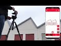
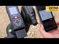
The Leica DISTO S910 and the DISTO X4 P2P package are ideal for determining corner points of a property. In combination with the DISTO Plan App the outlines can be drawn directly as a plan. Important points such as a tree or manhole cover can also be recorded in this way. The data can then be exported as a DWG or DXF file for further processing in CAD.
Tip: If you use the "Raw" format as export, the height differences of the measured points are included.
Fore more info:
https://shop.leica-geosystems.com/gb/leica-disto-s910-0
Видео Leica DISTO S910 and X4: How to easily capture a plot of land канала Leica Geosystems AG
Показать
Комментарии отсутствуют
Информация о видео
Другие видео канала
 Leica DISTO™ Plan App - How to measure a facade
 Leica Disto X4
 Leica Captivate Coding and Linework
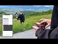 Leica DISTO S910, D810 and D510 (E7500i): How to easily determine a height profile?
 Leica DISTO S910: How to do a P2P Application
 InnoDraw 3D measuring system - using 3D LDM
 Tutorial: OrthoGraph 3D Measurement using Leica DISTO X3 or X4 with DST360
 Leica Disto X4 Demo
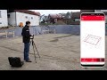 Leica DISTO™ Plan App - How to use the Earthworks Function
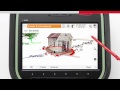 Stake a line and segment of a line
 Measure horizontally over obstractions with the Leica DISTO with the Smart Horizontal Mode
 Leica Geosystems | DISTO™ S910 - P2P and CAD Integration
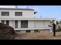 Leica DISTO™ - How to use the P2P Function? Best measuring tool for inaccessible objects 2019
 Leica DISTO X4 Outdoor Laser Distance Meter | Engineersupply
 Leica 3D Disto: Die Aufmaßlösung für Schreiner
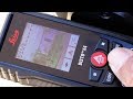 Best outdoor measuring tools 2019
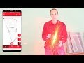 Leica DISTO™ Plan App - How to use Measure Plan
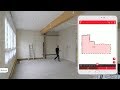 Leica DISTO™ Plan App - How to use Sketch Plan
 Leica disto S910